Pian Camuno elevation
Pian Camuno (Lombardy, Provincia di Brescia), Italy elevation is 199 meters and Pian Camuno elevation in feet is 653 ft above sea level [src 1]. Pian Camuno is a seat of a third-order administrative division (feature code) with elevation that is 123 meters (404 ft) smaller than average city elevation in Italy.
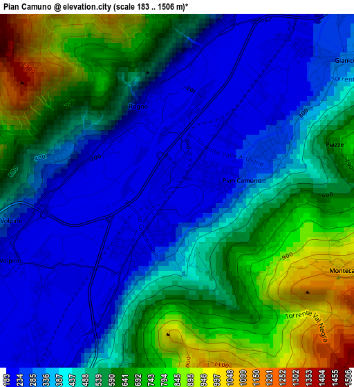
Below is the Elevation map of Pian Camuno, which displays elevation range with different colors. Scale of the first map is from 183 to 1506 m (600 to 4941 ft) with average elevation of 493.2 meters (=1618 ft) [note 1]
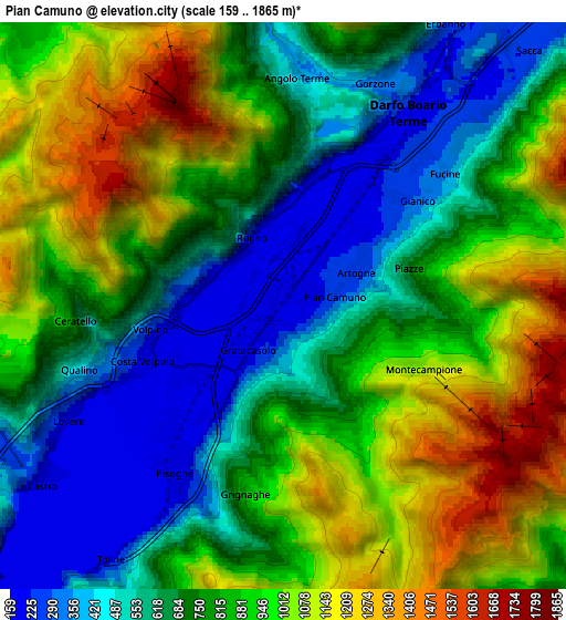
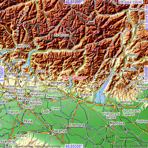
These maps also provides idea of topography and contour of this city, they are displayed at different zoom levels. More info about maps, scale and edge coordinates you can find below images.
| \ | Map #1 | Map #2 | Topo.Map |
| Scale [m] | 183..1506 m | 159..1865 m | × |
| Scale [ft] | 600..4941 ft | 522..6119 ft | × |
| Average | 493.2 m = 1618 ft | 804.8 m = 2640 ft | × |
| Width | 6.81 km = 4.2 mi | 13.62 km = 8.5 mi | 217.9 km = 135.4 mi |
| Height | 6.81 km = 4.2 mi | 13.62 km = 8.5 mi | 217.8 km = 135.3 mi |
| ↑Max Latitude | 45.872466° | 45.903055° | 46.81289° |
| Latitude at center | 45.84186° | 45.84186° | 45.84186° |
| ↓Min Latitude | 45.811237° | 45.780598° | 44.85358° |
| ← Min Longitude | 10.097865° | 10.053919° | 8.73556° |
| Longitude center | 10.14181° | 10.14181° | 10.14181° |
| →Max Longitude | 10.185755° | 10.229701° | 11.54806° |
Nearby cities:
Cities around Pian Camuno sort by population:
• Darfo Boario Terme elevation 222 m
6.6 km,  33°
33°
• Costa Volpino 194 m
3.5 km,  243°
243°
• Lovere 215 m
6.4 km, 240°
• Pisogne 190 m
4.5 km,  212°
212°
• Rogno 218 m
1.8 km,  335°
335°
• Artogne 230 m
2.4 km,  53°
53°
• Gianico 237 m
3.7 km,  44°
44°
• Angolo Terme 374 m
5.6 km,  6°
6°
• Gratacasolo 201 m
1.7 km, 214°
• Castro 199 m
7.2 km,  234°
234°
• Bossico 855 m
7.6 km,  258°
258°
• Darfo 221 m
5 km, 37°
Multilingual:
 En español:
Pian Camuno elevación 199 m.
 En France:
Pian Camuno élévation 199 m.
 Auf Deutsch:
Pian Camuno höhe über dem Meeresspiegel ist 199 m.

Sources and notes:
- [note 1] Map square and city borders are not equal. Map elevation data is calculated only from area inside that square.
- [src 1] Elevation data from geonames database provided with same terms of usage.
- [src 2] The elevation map of Pian Camuno is generated using elevation data from NASA's 3 arcsec (90m) resolution SRTM data.
- [src 3] Base (background) map © OpenStreetMap contributors tiles are generated by Geofabrik and OpenTopoMap.
Copyright & License:
This Pian Camuno Elevation Map is licensed under CC BY-SA. You may reuse any part from this page, if you give a proper credit by linking to this URL:
 More info on terms of use page.