Pianura elevation
Pianura (Campania, Napoli), Italy elevation is 160 meters and Pianura elevation in feet is 525 ft above sea level [src 1]. Pianura is a populated place (feature code) with elevation that is 162 meters (531 ft) smaller than average city elevation in Italy.
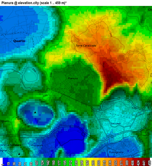
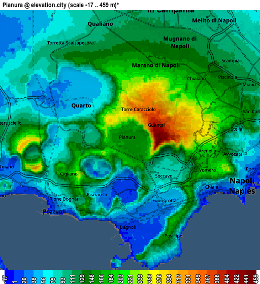
Below is the Elevation map of Pianura, which displays elevation range with different colors. Scale of the first map is from 1 to 459 m (3 to 1506 ft) with average elevation of 159.2 meters (=522 ft) [note 1]
These maps also provides idea of topography and contour of this city, they are displayed at different zoom levels. More info about maps, scale and edge coordinates you can find below images.
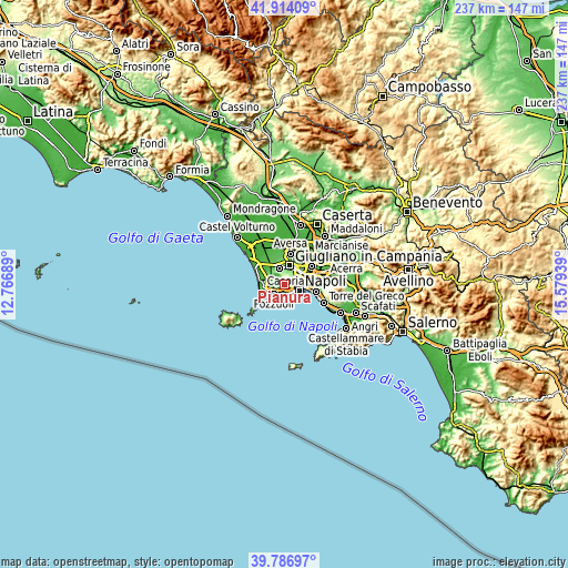
| \ | Map #1 | Map #2 | Topo.Map |
| Scale [m] | 1..459 m | -17..459 m | × |
| Scale [ft] | 3..1506 ft | -56..1506 ft | × |
| Average | 159.2 m = 522 ft | 118.6 m = 389 ft | × |
| Width | 7.39 km = 4.6 mi | 14.78 km = 9.2 mi | 236.5 km = 147 mi |
| Height | 7.39 km = 4.6 mi | 14.78 km = 9.2 mi | 236.5 km = 147 mi |
| ↑Max Latitude | 40.892298° | 40.92551° | 41.91409° |
| Latitude at center | 40.85907° | 40.85907° | 40.85907° |
| ↓Min Latitude | 40.825825° | 40.792563° | 39.78697° |
| ← Min Longitude | 14.129195° | 14.085249° | 12.76689° |
| Longitude center | 14.17314° | 14.17314° | 14.17314° |
| →Max Longitude | 14.217085° | 14.261031° | 15.57939° |
Nearby cities:
Cities around Pianura sort by population:
• Fuorigrotta elevation 53 m
3.6 km,  141°
141°
• Arenella 233 m
4.2 km,  92°
92°
• Marano di Napoli 167 m
4.4 km,  16°
16°
• Soccavo 88 m
2.2 km,  132°
132°
• Vomero 106 m
5.2 km,  110°
110°
• Chiaia 6 m
5.4 km,  123°
123°
• Quarto 52 m
3.3 km,  310°
310°
• Chiaiano 229 m
3.8 km,  49°
49°
• Bagnoli 3 m
5.1 km,  184°
184°
• Posillipo 45 m
5.6 km,  156°
156°
• Calvizzano 134 m
5.5 km,  11°
11°
• Torre Caracciolo 340 m
1.9 km, 14°
Multilingual:
 En español:
Pianura elevación 160 m.
 En France:
Pianura élévation 160 m.


Sources and notes:
- [note 1] Map square and city borders are not equal. Map elevation data is calculated only from area inside that square.
- [src 1] Elevation data from geonames database provided with same terms of usage.
- [src 2] The elevation map of Pianura is generated using elevation data from NASA's 3 arcsec (90m) resolution SRTM data.
- [src 3] Base (background) map © OpenStreetMap contributors tiles are generated by Geofabrik and OpenTopoMap.
Copyright & License:
This Pianura Elevation Map is licensed under CC BY-SA. You may reuse any part from this page, if you give a proper credit by linking to this URL:
 More info on terms of use page.