Picciano elevation
Picciano (Abruzzo, Provincia di Pescara), Italy elevation is 163 meters and Picciano elevation in feet is 535 ft above sea level [src 1]. Picciano is a seat of a third-order administrative division (feature code) with elevation that is 159 meters (522 ft) smaller than average city elevation in Italy.
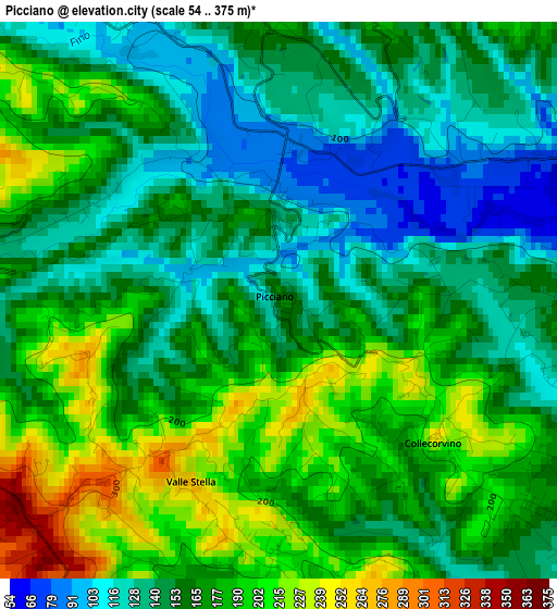
Below is the Elevation map of Picciano, which displays elevation range with different colors. Scale of the first map is from 54 to 375 m (177 to 1230 ft) with average elevation of 165 meters (=541 ft) [note 1]
These maps also provides idea of topography and contour of this city, they are displayed at different zoom levels. More info about maps, scale and edge coordinates you can find below images.
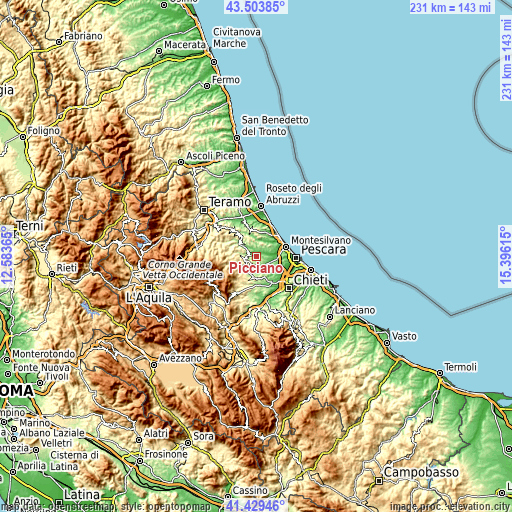
| \ | Map #1 | Topo.Map |
| Scale [m] | 54..375 m | × |
| Scale [ft] | 177..1230 ft | × |
| Average | 165 m = 541 ft | × |
| Width | 7.21 km = 4.5 mi | 230.7 km = 143.4 mi |
| Height | 7.21 km = 4.5 mi | 230.6 km = 143.3 mi |
| ↑Max Latitude | 42.507654° | 43.50385° |
| Latitude at center | 42.47525° | 42.47525° |
| ↓Min Latitude | 42.442829° | 41.42946° |
| ← Min Longitude | 13.945955° | 12.58365° |
| Longitude center | 13.9899° | 13.9899° |
| →Max Longitude | 14.033845° | 15.39615° |
Nearby cities:
Cities around Picciano sort by population:
• Penne elevation 415 m
5.6 km,  245°
245°
• Loreto Aprutino 298 m
5 km,  188°
188°
• Cappelle sul Tavo 30 m
9.6 km,  88°
88°
• Pianella 197 m
9.7 km,  150°
150°
• Città Sant'Angelo 184 m
7.2 km,  54°
54°
• Collecorvino 226 m
2.7 km,  128°
128°
• Fonte Umano-San Martino Alta 114 m
10.9 km,  62°
62°
• Barberi 87 m
5.8 km, 131°
• Moscufo 241 m
7.5 km,  135°
135°
• Castilenti 266 m
8.8 km,  317°
317°
• Castiglione Messer Raimondo 286 m
11 km,  304°
304°
• Elice 238 m
5.5 km,  343°
343°
Multilingual:
 En español:
Picciano elevación 163 m.
 En France:
Picciano élévation 163 m.
 Auf Deutsch:
Picciano höhe über dem Meeresspiegel ist 163 m.

Sources and notes:
- [note 1] Map square and city borders are not equal. Map elevation data is calculated only from area inside that square.
- [src 1] Elevation data from geonames database provided with same terms of usage.
- [src 2] The elevation map of Picciano is generated using elevation data from NASA's 3 arcsec (90m) resolution SRTM data.
- [src 3] Base (background) map © OpenStreetMap contributors tiles are generated by Geofabrik and OpenTopoMap.
Copyright & License:
This Picciano Elevation Map is licensed under CC BY-SA. You may reuse any part from this page, if you give a proper credit by linking to this URL:
 More info on terms of use page.