Piobesi Torinese elevation
Piobesi Torinese (Piedmont, Provincia di Cuneo), Italy elevation is 253 meters and Piobesi Torinese elevation in feet is 830 ft above sea level [src 1]. Piobesi Torinese is a populated place (feature code) with elevation that is 69 meters (226 ft) smaller than average city elevation in Italy.
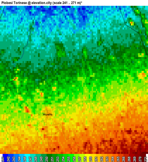
Below is the Elevation map of Piobesi Torinese, which displays elevation range with different colors. Scale of the first map is from 241 to 271 m (791 to 889 ft) with average elevation of 254.3 meters (=834 ft) [note 1]
These maps also provides idea of topography and contour of this city, they are displayed at different zoom levels. More info about maps, scale and edge coordinates you can find below images.
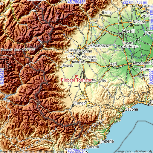
| \ | Map #1 | Topo.Map |
| Scale [m] | 241..271 m | × |
| Scale [ft] | 791..889 ft | × |
| Average | 254.3 m = 834 ft | × |
| Width | 6.94 km = 4.3 mi | 222 km = 137.9 mi |
| Height | 6.94 km = 4.3 mi | 222 km = 137.9 mi |
| ↑Max Latitude | 44.797862° | 45.75645° |
| Latitude at center | 44.76667° | 44.76667° |
| ↓Min Latitude | 44.735461° | 43.75963° |
| ← Min Longitude | 7.572725° | 6.21042° |
| Longitude center | 7.61667° | 7.61667° |
| →Max Longitude | 7.660615° | 9.02292° |
Nearby cities:
Cities around Piobesi Torinese sort by population:
• Racconigi elevation 269 m
4.9 km,  90°
90°
• Moretta 257 m
6.4 km,  264°
264°
• Pancalieri 247 m
7.8 km,  341°
341°
• Casalgrasso 243 m
5.8 km,  6°
6°
• Polonghera 248 m
4.3 km, 337°
• Lombriasco 243 m
8.4 km, 10°
• Murello 261 m
2 km,  217°
217°
• Torre San Giorgio 262 m
7.8 km,  243°
243°
• Villanova Solaro 268 m
5.3 km, 219°
• Cavallerleone 270 m
4.8 km,  128°
128°
• Faule 245 m
5.1 km,  330°
330°
• Ruffia 281 m
6.8 km,  188°
188°
Multilingual:
 En español:
Piobesi Torinese elevación 253 m.
 En France:
Piobesi Torinese élévation 253 m.
 Auf Deutsch:
Piobesi Torinese höhe über dem Meeresspiegel ist 253 m.

Sources and notes:
- [note 1] Map square and city borders are not equal. Map elevation data is calculated only from area inside that square.
- [src 1] Elevation data from geonames database provided with same terms of usage.
- [src 2] The elevation map of Piobesi Torinese is generated using elevation data from NASA's 3 arcsec (90m) resolution SRTM data.
- [src 3] Base (background) map © OpenStreetMap contributors tiles are generated by Geofabrik and OpenTopoMap.
Copyright & License:
This Piobesi Torinese Elevation Map is licensed under CC BY-SA. You may reuse any part from this page, if you give a proper credit by linking to this URL:
 More info on terms of use page.