Piteglio elevation
Piteglio (Tuscany, Provincia di Pistoia), Italy elevation is 671 meters and Piteglio elevation in feet is 2201 ft above sea level [src 1]. Piteglio is a seat of a third-order administrative division (feature code) with elevation that is 349 meters (1145 ft) bigger than average city elevation in Italy.
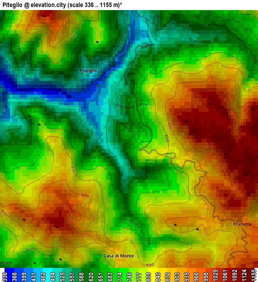
Below is the Elevation map of Piteglio, which displays elevation range with different colors. Scale of the first map is from 336 to 1155 m (1102 to 3789 ft) with average elevation of 766.5 meters (=2515 ft) [note 1]
These maps also provides idea of topography and contour of this city, they are displayed at different zoom levels. More info about maps, scale and edge coordinates you can find below images.
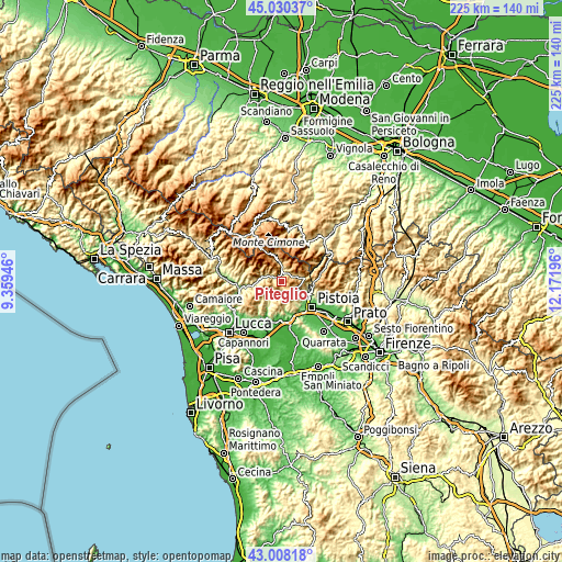
| \ | Map #1 | Topo.Map |
| Scale [m] | 336..1155 m | × |
| Scale [ft] | 1102..3789 ft | × |
| Average | 766.5 m = 2515 ft | × |
| Width | 7.03 km = 4.4 mi | 224.8 km = 139.7 mi |
| Height | 7.03 km = 4.4 mi | 224.8 km = 139.7 mi |
| ↑Max Latitude | 44.059488° | 45.03037° |
| Latitude at center | 44.0279° | 44.0279° |
| ↓Min Latitude | 43.996295° | 43.00818° |
| ← Min Longitude | 10.721765° | 9.35946° |
| Longitude center | 10.76571° | 10.76571° |
| →Max Longitude | 10.809655° | 12.17196° |
Nearby cities:
Cities around Piteglio sort by population:
• Montecatini-Terme elevation 30 m
16.3 km,  178°
178°
• Pieve a Nievole 28 m
16.5 km,  170°
170°
• Campo Tizzoro 741 m
7.1 km,  79°
79°
• San Marcello Pistoiese 618 m
3.8 km,  35°
35°
• Stazione Masotti 74 m
14.9 km,  151°
151°
• Villa Basilica 335 m
14.9 km,  220°
220°
• Cutigliano 704 m
8.1 km,  354°
354°
• Massa 223 m
13.3 km,  187°
187°
• Serravalle Pistoiese 176 m
14.6 km,  158°
158°
• Uzzano 254 m
15.3 km,  198°
198°
• Abetone 1373 m
15.4 km,  328°
328°
• Marliana 456 m
10.5 km, 178°
Multilingual:
 En español:
Piteglio elevación 671 m.
 En France:
Piteglio élévation 671 m.
 Auf Deutsch:
Piteglio höhe über dem Meeresspiegel ist 671 m.

Sources and notes:
- [note 1] Map square and city borders are not equal. Map elevation data is calculated only from area inside that square.
- [src 1] Elevation data from geonames database provided with same terms of usage.
- [src 2] The elevation map of Piteglio is generated using elevation data from NASA's 3 arcsec (90m) resolution SRTM data.
- [src 3] Base (background) map © OpenStreetMap contributors tiles are generated by Geofabrik and OpenTopoMap.
Copyright & License:
This Piteglio Elevation Map is licensed under CC BY-SA. You may reuse any part from this page, if you give a proper credit by linking to this URL:
 More info on terms of use page.