Pitigliano elevation
Pitigliano (Tuscany, Provincia di Grosseto), Italy elevation is 336 meters and Pitigliano elevation in feet is 1102 ft above sea level [src 1]. Pitigliano is a seat of a third-order administrative division (feature code) with elevation that is 14 meters (46 ft) bigger than average city elevation in Italy.
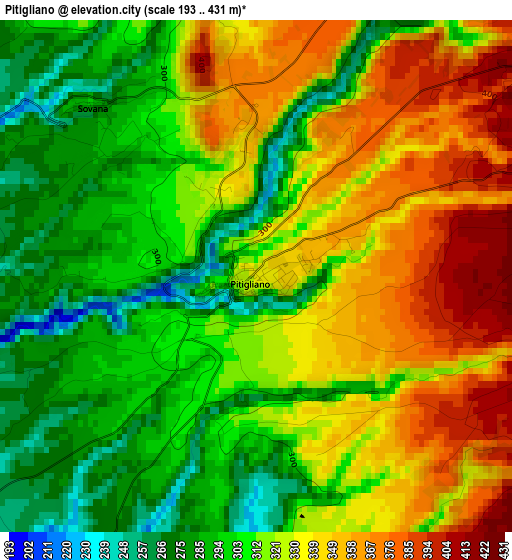
Below is the Elevation map of Pitigliano, which displays elevation range with different colors. Scale of the first map is from 193 to 431 m (633 to 1414 ft) with average elevation of 320 meters (=1050 ft) [note 1]
These maps also provides idea of topography and contour of this city, they are displayed at different zoom levels. More info about maps, scale and edge coordinates you can find below images.
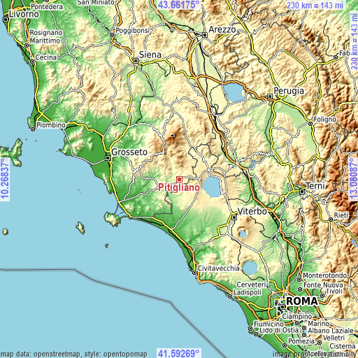
| \ | Map #1 | Topo.Map |
| Scale [m] | 193..431 m | × |
| Scale [ft] | 633..1414 ft | × |
| Average | 320 m = 1050 ft | × |
| Width | 7.19 km = 4.5 mi | 230.1 km = 143 mi |
| Height | 7.19 km = 4.5 mi | 230 km = 142.9 mi |
| ↑Max Latitude | 42.668141° | 43.66175° |
| Latitude at center | 42.63582° | 42.63582° |
| ↓Min Latitude | 42.603482° | 41.59269° |
| ← Min Longitude | 11.630675° | 10.26837° |
| Longitude center | 11.67462° | 11.67462° |
| →Max Longitude | 11.718565° | 13.08087° |
Nearby cities:
Cities around Pitigliano sort by population:
• Manciano elevation 383 m
13.8 km,  247°
247°
• Valentano 510 m
14.9 km,  122°
122°
• Grotte di Castro 478 m
16.5 km,  74°
74°
• Ischia di Castro 412 m
12.2 km,  146°
146°
• Farnese 354 m
10.5 km,  156°
156°
• Gradoli 461 m
14.9 km,  86°
86°
• Cellere 359 m
16 km, 150°
• Castell'Azzara 801 m
15.3 km,  7°
7°
• Onano 480 m
13.1 km,  61°
61°
• Latera 521 m
12.7 km, 93°
• Sorano 409 m
6.2 km,  35°
35°
• Semproniano 586 m
15.1 km,  313°
313°
Multilingual:
 En español:
Pitigliano elevación 336 m.
 En France:
Pitigliano élévation 336 m.
 Auf Deutsch:
Pitigliano höhe über dem Meeresspiegel ist 336 m.

Sources and notes:
- [note 1] Map square and city borders are not equal. Map elevation data is calculated only from area inside that square.
- [src 1] Elevation data from geonames database provided with same terms of usage.
- [src 2] The elevation map of Pitigliano is generated using elevation data from NASA's 3 arcsec (90m) resolution SRTM data.
- [src 3] Base (background) map © OpenStreetMap contributors tiles are generated by Geofabrik and OpenTopoMap.
Copyright & License:
This Pitigliano Elevation Map is licensed under CC BY-SA. You may reuse any part from this page, if you give a proper credit by linking to this URL:
 More info on terms of use page.