Ploaghe elevation
Ploaghe (Sardinia, Provincia di Sassari), Italy elevation is 438 meters and Ploaghe elevation in feet is 1437 ft above sea level [src 1]. Ploaghe is a seat of a third-order administrative division (feature code) with elevation that is 116 meters (381 ft) bigger than average city elevation in Italy.
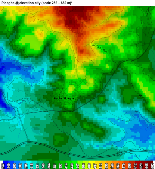
Below is the Elevation map of Ploaghe, which displays elevation range with different colors. Scale of the first map is from 232 to 662 m (761 to 2172 ft) with average elevation of 390.1 meters (=1280 ft) [note 1]
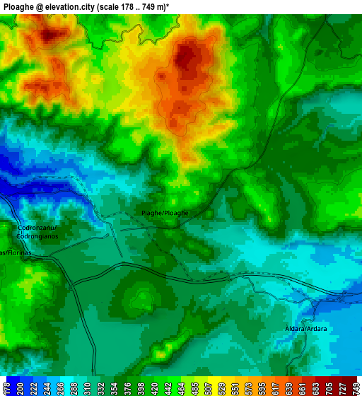
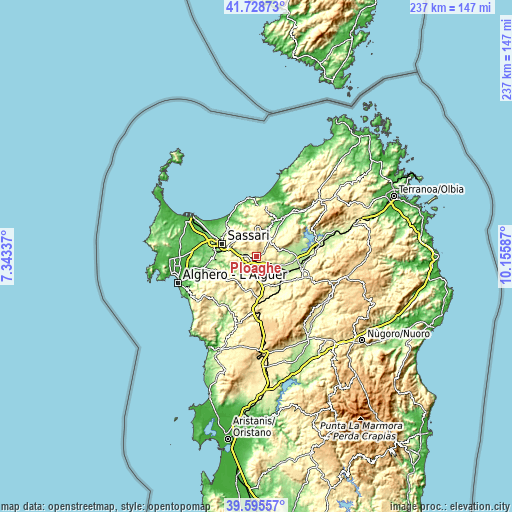
These maps also provides idea of topography and contour of this city, they are displayed at different zoom levels. More info about maps, scale and edge coordinates you can find below images.
| \ | Map #1 | Map #2 | Topo.Map |
| Scale [m] | 232..662 m | 178..749 m | × |
| Scale [ft] | 761..2172 ft | 584..2457 ft | × |
| Average | 390.1 m = 1280 ft | 385.9 m = 1266 ft | × |
| Width | 7.41 km = 4.6 mi | 14.82 km = 9.2 mi | 237.2 km = 147.4 mi |
| Height | 7.41 km = 4.6 mi | 14.82 km = 9.2 mi | 237.2 km = 147.4 mi |
| ↑Max Latitude | 40.704003° | 40.737309° | 41.72873° |
| Latitude at center | 40.67068° | 40.67068° | 40.67068° |
| ↓Min Latitude | 40.637341° | 40.603984° | 39.59557° |
| ← Min Longitude | 8.705675° | 8.661729° | 7.34337° |
| Longitude center | 8.74962° | 8.74962° | 8.74962° |
| →Max Longitude | 8.793565° | 8.837511° | 10.15587° |
Nearby cities:
Cities around Ploaghe sort by population:
• Nulvi elevation 481 m
12.7 km,  357°
357°
• Osilo 616 m
10.5 km,  320°
320°
• Chiaramonti 417 m
10.5 km,  34°
34°
• Florinas 412 m
7.5 km,  251°
251°
• Codrongianos 366 m
6 km, 254°
• Siligo 407 m
10.8 km,  189°
189°
• Muros 294 m
11.2 km,  274°
274°
• Ardara 302 m
7.5 km,  137°
137°
• Banari 437 m
11.9 km,  200°
200°
• Cargeghe 322 m
11.3 km, 269°
• Martis 298 m
12.9 km,  22°
22°
• Bessude 423 m
13.1 km, 188°
Multilingual:
 En español:
Ploaghe elevación 438 m.
 En France:
Ploaghe élévation 438 m.


Sources and notes:
- [note 1] Map square and city borders are not equal. Map elevation data is calculated only from area inside that square.
- [src 1] Elevation data from geonames database provided with same terms of usage.
- [src 2] The elevation map of Ploaghe is generated using elevation data from NASA's 3 arcsec (90m) resolution SRTM data.
- [src 3] Base (background) map © OpenStreetMap contributors tiles are generated by Geofabrik and OpenTopoMap.
Copyright & License:
This Ploaghe Elevation Map is licensed under CC BY-SA. You may reuse any part from this page, if you give a proper credit by linking to this URL:
 More info on terms of use page.