Ponte Ronca elevation
Ponte Ronca (Emilia-Romagna, Bologna), Italy elevation is 64 meters and Ponte Ronca elevation in feet is 210 ft above sea level [src 1]. Ponte Ronca is a populated place (feature code) with elevation that is 258 meters (846 ft) smaller than average city elevation in Italy.
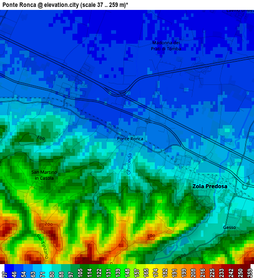
Below is the Elevation map of Ponte Ronca, which displays elevation range with different colors. Scale of the first map is from 37 to 259 m (121 to 850 ft) with average elevation of 85.3 meters (=280 ft) [note 1]
These maps also provides idea of topography and contour of this city, they are displayed at different zoom levels. More info about maps, scale and edge coordinates you can find below images.
| \ | Map #1 | Topo.Map |
| Scale [m] | 37..259 m | × |
| Scale [ft] | 121..850 ft | × |
| Average | 85.3 m = 280 ft | × |
| Width | 6.97 km = 4.3 mi | 223 km = 138.6 mi |
| Height | 6.97 km = 4.3 mi | 223 km = 138.6 mi |
| ↑Max Latitude | 44.532995° | 45.49601° |
| Latitude at center | 44.50166° | 44.50166° |
| ↓Min Latitude | 44.470308° | 43.49006° |
| ← Min Longitude | 11.145785° | 9.78348° |
| Longitude center | 11.18973° | 11.18973° |
| →Max Longitude | 11.233675° | 12.59598° |
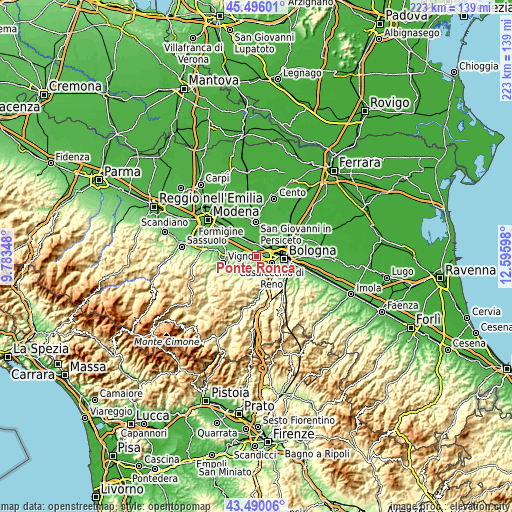
Nearby cities:
Cities around Ponte Ronca sort by population:
• Casalecchio di Reno elevation 71 m
7.4 km,  113°
113°
• Zola Predosa 82 m
2.6 km,  120°
120°
• Anzola dell'Emilia 41 m
4.7 km,  15°
15°
• Calderara di Reno 28 m
9.4 km,  43°
43°
• Bazzano 88 m
8.2 km,  270°
270°
• Crespellano 65 m
4.7 km,  284°
284°
• Borgonuovo 101 m
9.8 km,  138°
138°
• Calderino 113 m
4.9 km,  171°
171°
• Riale 78 m
4 km, 120°
• Calcara 52 m
6.7 km,  318°
318°
• Cavazzona 42 m
9.7 km, 324°
• Monte San Giovanni 163 m
9.2 km,  188°
188°
Multilingual:
 En español:
Ponte Ronca elevación 64 m.
 En France:
Ponte Ronca élévation 64 m.
 Auf Deutsch:
Ponte Ronca höhe über dem Meeresspiegel ist 64 m.

Sources and notes:
- [note 1] Map square and city borders are not equal. Map elevation data is calculated only from area inside that square.
- [src 1] Elevation data from geonames database provided with same terms of usage.
- [src 2] The elevation map of Ponte Ronca is generated using elevation data from NASA's 3 arcsec (90m) resolution SRTM data.
- [src 3] Base (background) map © OpenStreetMap contributors tiles are generated by Geofabrik and OpenTopoMap.
Copyright & License:
This Ponte Ronca Elevation Map is licensed under CC BY-SA. You may reuse any part from this page, if you give a proper credit by linking to this URL:
 More info on terms of use page.