Pralormo elevation
Pralormo (Piedmont, Torino), Italy elevation is 308 meters and Pralormo elevation in feet is 1010 ft above sea level [src 1]. Pralormo is a seat of a third-order administrative division (feature code) with elevation that is 14 meters (46 ft) smaller than average city elevation in Italy.
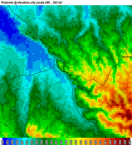
Below is the Elevation map of Pralormo, which displays elevation range with different colors. Scale of the first map is from 249 to 363 m (817 to 1191 ft) with average elevation of 289.5 meters (=950 ft) [note 1]
These maps also provides idea of topography and contour of this city, they are displayed at different zoom levels. More info about maps, scale and edge coordinates you can find below images.
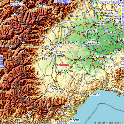
| \ | Map #1 | Topo.Map |
| Scale [m] | 249..363 m | × |
| Scale [ft] | 817..1191 ft | × |
| Average | 289.5 m = 950 ft | × |
| Width | 6.93 km = 4.3 mi | 221.7 km = 137.8 mi |
| Height | 6.93 km = 4.3 mi | 221.7 km = 137.8 mi |
| ↑Max Latitude | 44.890902° | 45.84793° |
| Latitude at center | 44.85976° | 44.85976° |
| ↓Min Latitude | 44.828602° | 43.85433° |
| ← Min Longitude | 7.860455° | 6.49815° |
| Longitude center | 7.9044° | 7.9044° |
| →Max Longitude | 7.948345° | 9.31065° |
Nearby cities:
Cities around Pralormo sort by population:
• Poirino elevation 257 m
8.2 km,  325°
325°
• Villanova d'Asti 260 m
9.6 km,  15°
15°
• Montà 310 m
6.4 km,  141°
141°
• Valfenera 276 m
6.6 km,  45°
45°
• Ceresole Alba 304 m
9.3 km,  224°
224°
• Cisterna d'Asti 307 m
8.5 km,  116°
116°
• Ferrere 237 m
7.3 km,  75°
75°
• Cellarengo 319 m
3.3 km, 81°
• Dusino 267 m
9 km,  35°
35°
• Isolabella 263 m
5.2 km,  4°
4°
• Monteu Roero 363 m
9.1 km,  165°
165°
• Santo Stefano Roero 325 m
8.4 km,  160°
160°
Multilingual:
 En español:
Pralormo elevación 308 m.
 En France:
Pralormo élévation 308 m.
 Auf Deutsch:
Pralormo höhe über dem Meeresspiegel ist 308 m.

Sources and notes:
- [note 1] Map square and city borders are not equal. Map elevation data is calculated only from area inside that square.
- [src 1] Elevation data from geonames database provided with same terms of usage.
- [src 2] The elevation map of Pralormo is generated using elevation data from NASA's 3 arcsec (90m) resolution SRTM data.
- [src 3] Base (background) map © OpenStreetMap contributors tiles are generated by Geofabrik and OpenTopoMap.
Copyright & License:
This Pralormo Elevation Map is licensed under CC BY-SA. You may reuse any part from this page, if you give a proper credit by linking to this URL:
 More info on terms of use page.