Quasano elevation
Quasano (Apulia, Bari), Italy elevation is 357 meters and Quasano elevation in feet is 1171 ft above sea level [src 1]. Quasano is a seat of a third-order administrative division (feature code) with elevation that is 35 meters (115 ft) bigger than average city elevation in Italy.
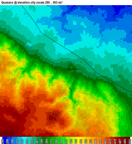
Below is the Elevation map of Quasano, which displays elevation range with different colors. Scale of the first map is from 290 to 503 m (951 to 1650 ft) with average elevation of 380.8 meters (=1249 ft) [note 1]
These maps also provides idea of topography and contour of this city, they are displayed at different zoom levels. More info about maps, scale and edge coordinates you can find below images.
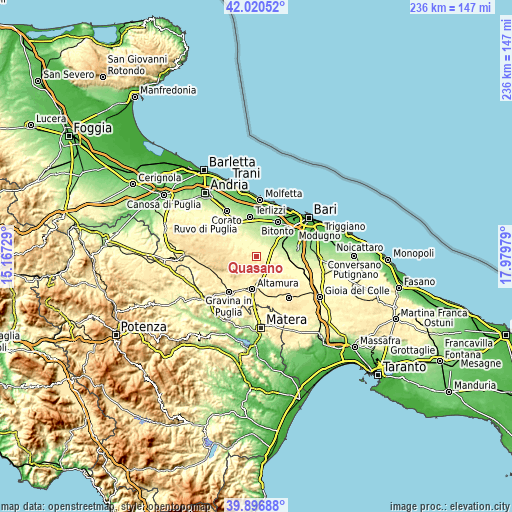
| \ | Map #1 | Topo.Map |
| Scale [m] | 290..503 m | × |
| Scale [ft] | 951..1650 ft | × |
| Average | 380.8 m = 1249 ft | × |
| Width | 7.38 km = 4.6 mi | 236.1 km = 146.7 mi |
| Height | 7.38 km = 4.6 mi | 236.1 km = 146.7 mi |
| ↑Max Latitude | 41.000414° | 42.02052° |
| Latitude at center | 40.96724° | 40.96724° |
| ↓Min Latitude | 40.934049° | 39.89688° |
| ← Min Longitude | 16.529595° | 15.16729° |
| Longitude center | 16.57354° | 16.57354° |
| →Max Longitude | 16.617485° | 17.97979° |
Nearby cities:
Cities around Quasano sort by population:
• Altamura elevation 475 m
15.8 km,  187°
187°
• Bitonto 117 m
18.7 km,  31°
31°
• Terlizzi 196 m
18.1 km,  352°
352°
• Ruvo di Puglia 259 m
18.3 km,  335°
335°
• Palo del Colle 164 m
14.7 km,  47°
47°
• Grumo Appula 190 m
12.3 km,  66°
66°
• Cassano delle Murge 332 m
18.2 km,  117°
117°
• Bitetto 139 m
16.8 km,  60°
60°
• Toritto 237 m
9.5 km, 69°
• Palombaio 199 m
11.9 km,  14°
14°
• Binetto 174 m
13 km, 61°
• Mariotto 241 m
9.3 km, 353°
Multilingual:
 En español:
Quasano elevación 357 m.
 En France:
Quasano élévation 357 m.


Sources and notes:
- [note 1] Map square and city borders are not equal. Map elevation data is calculated only from area inside that square.
- [src 1] Elevation data from geonames database provided with same terms of usage.
- [src 2] The elevation map of Quasano is generated using elevation data from NASA's 3 arcsec (90m) resolution SRTM data.
- [src 3] Base (background) map © OpenStreetMap contributors tiles are generated by Geofabrik and OpenTopoMap.
Copyright & License:
This Quasano Elevation Map is licensed under CC BY-SA. You may reuse any part from this page, if you give a proper credit by linking to this URL:
 More info on terms of use page.