Quattordio elevation
Quattordio (Piedmont, Provincia di Alessandria), Italy elevation is 124 meters and Quattordio elevation in feet is 407 ft above sea level [src 1]. Quattordio is a seat of a third-order administrative division (feature code) with elevation that is 198 meters (650 ft) smaller than average city elevation in Italy.
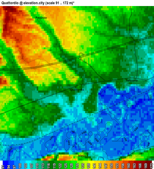
Below is the Elevation map of Quattordio, which displays elevation range with different colors. Scale of the first map is from 91 to 172 m (299 to 564 ft) with average elevation of 119.7 meters (=393 ft) [note 1]
These maps also provides idea of topography and contour of this city, they are displayed at different zoom levels. More info about maps, scale and edge coordinates you can find below images.
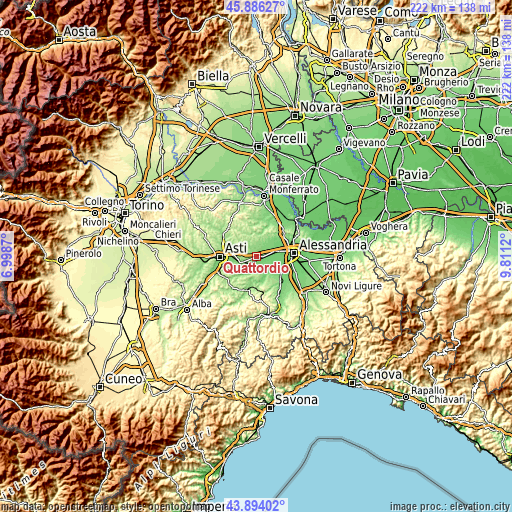
| \ | Map #1 | Topo.Map |
| Scale [m] | 91..172 m | × |
| Scale [ft] | 299..564 ft | × |
| Average | 119.7 m = 393 ft | × |
| Width | 6.92 km = 4.3 mi | 221.5 km = 137.6 mi |
| Height | 6.92 km = 4.3 mi | 221.5 km = 137.6 mi |
| ↑Max Latitude | 44.92989° | 45.88627° |
| Latitude at center | 44.89877° | 44.89877° |
| ↓Min Latitude | 44.867633° | 43.89402° |
| ← Min Longitude | 8.361005° | 6.9987° |
| Longitude center | 8.40495° | 8.40495° |
| →Max Longitude | 8.448895° | 9.8112° |
Nearby cities:
Cities around Quattordio sort by population:
• Felizzano elevation 113 m
2.4 km,  88°
88°
• Solero 102 m
8.4 km,  74°
74°
• Fubine 161 m
7.4 km,  14°
14°
• Castello di Annone 114 m
7.3 km,  252°
252°
• Quargnento 119 m
8.4 km,  51°
51°
• Rocchetta Tanaro 107 m
6.5 km,  226°
226°
• Oviglio 109 m
7.7 km,  122°
122°
• Refrancore 153 m
6.6 km,  309°
309°
• Cerro Tanaro 110 m
4.6 km, 232°
• Masio 134 m
3.2 km,  176°
176°
• Bergamasco 126 m
8.9 km,  153°
153°
• Cortiglione 201 m
9.3 km,  203°
203°
Multilingual:
 En español:
Quattordio elevación 124 m.
 En France:
Quattordio élévation 124 m.
 Auf Deutsch:
Quattordio höhe über dem Meeresspiegel ist 124 m.

Sources and notes:
- [note 1] Map square and city borders are not equal. Map elevation data is calculated only from area inside that square.
- [src 1] Elevation data from geonames database provided with same terms of usage.
- [src 2] The elevation map of Quattordio is generated using elevation data from NASA's 3 arcsec (90m) resolution SRTM data.
- [src 3] Base (background) map © OpenStreetMap contributors tiles are generated by Geofabrik and OpenTopoMap.
Copyright & License:
This Quattordio Elevation Map is licensed under CC BY-SA. You may reuse any part from this page, if you give a proper credit by linking to this URL:
 More info on terms of use page.