Quero elevation
Quero (Veneto, Provincia di Belluno), Italy elevation is 274 meters and Quero elevation in feet is 899 ft above sea level [src 1]. Quero is a seat of a third-order administrative division (feature code) with elevation that is 48 meters (157 ft) smaller than average city elevation in Italy.
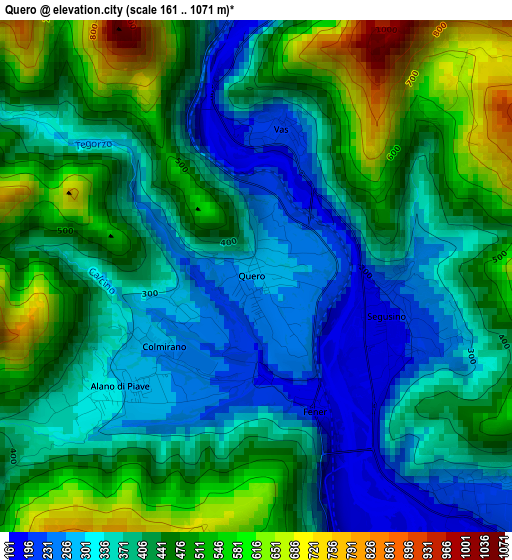
Below is the Elevation map of Quero, which displays elevation range with different colors. Scale of the first map is from 161 to 1071 m (528 to 3514 ft) with average elevation of 418 meters (=1371 ft) [note 1]
These maps also provides idea of topography and contour of this city, they are displayed at different zoom levels. More info about maps, scale and edge coordinates you can find below images.
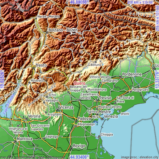
| \ | Map #1 | Topo.Map |
| Scale [m] | 161..1071 m | × |
| Scale [ft] | 528..3514 ft | × |
| Average | 418 m = 1371 ft | × |
| Width | 6.8 km = 4.2 mi | 217.5 km = 135.1 mi |
| Height | 6.8 km = 4.2 mi | 217.5 km = 135.1 mi |
| ↑Max Latitude | 45.951502° | 46.89058° |
| Latitude at center | 45.92094° | 45.92094° |
| ↓Min Latitude | 45.890361° | 44.93406° |
| ← Min Longitude | 11.887565° | 10.52526° |
| Longitude center | 11.93151° | 11.93151° |
| →Max Longitude | 11.975455° | 13.33776° |
Nearby cities:
Cities around Quero sort by population:
• Valdobbiadene elevation 223 m
4.8 km,  124°
124°
• Cavaso del Tomba 245 m
7.2 km,  200°
200°
• Covolo-Levada 165 m
9.9 km,  144°
144°
• Possagno 235 m
8.9 km, 204°
• Onigo 172 m
8.5 km,  147°
147°
• Pederobba 224 m
5.2 km,  164°
164°
• Caniezza 213 m
8 km, 198°
• Segusino 201 m
1.9 km,  103°
103°
• Bigolino 174 m
8.9 km,  132°
132°
• Alano di Piave 299 m
2.4 km,  228°
228°
• Vas 216 m
1.9 km,  9°
9°
• Monfumo 195 m
10.1 km,  184°
184°
Multilingual:
 En español:
Quero elevación 274 m.
 En France:
Quero élévation 274 m.


Sources and notes:
- [note 1] Map square and city borders are not equal. Map elevation data is calculated only from area inside that square.
- [src 1] Elevation data from geonames database provided with same terms of usage.
- [src 2] The elevation map of Quero is generated using elevation data from NASA's 3 arcsec (90m) resolution SRTM data.
- [src 3] Base (background) map © OpenStreetMap contributors tiles are generated by Geofabrik and OpenTopoMap.
Copyright & License:
This Quero Elevation Map is licensed under CC BY-SA. You may reuse any part from this page, if you give a proper credit by linking to this URL:
 More info on terms of use page.