Reino elevation
Reino (Campania, Provincia di Benevento), Italy elevation is 406 meters and Reino elevation in feet is 1332 ft above sea level [src 1]. Reino is a seat of a third-order administrative division (feature code) with elevation that is 84 meters (276 ft) bigger than average city elevation in Italy.
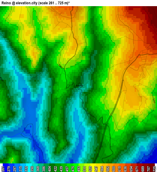
Below is the Elevation map of Reino, which displays elevation range with different colors. Scale of the first map is from 261 to 725 m (856 to 2379 ft) with average elevation of 457.8 meters (=1502 ft) [note 1]
These maps also provides idea of topography and contour of this city, they are displayed at different zoom levels. More info about maps, scale and edge coordinates you can find below images.
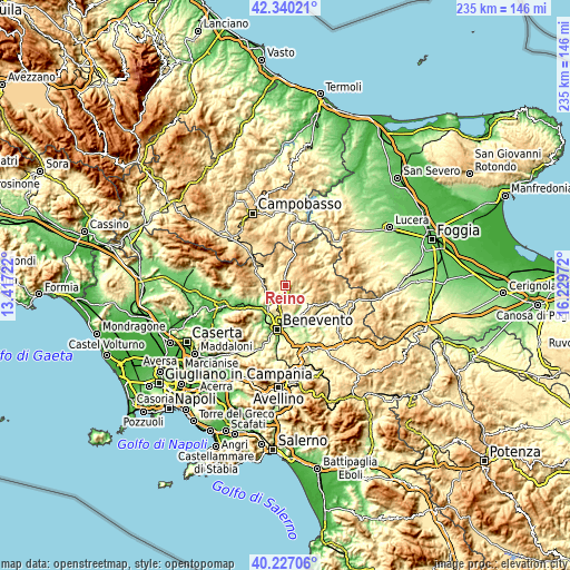
| \ | Map #1 | Topo.Map |
| Scale [m] | 261..725 m | × |
| Scale [ft] | 856..2379 ft | × |
| Average | 457.8 m = 1502 ft | × |
| Width | 7.34 km = 4.6 mi | 235 km = 146 mi |
| Height | 7.34 km = 4.6 mi | 235 km = 146 mi |
| ↑Max Latitude | 41.3252° | 42.34021° |
| Latitude at center | 41.29219° | 41.29219° |
| ↓Min Latitude | 41.259163° | 40.22706° |
| ← Min Longitude | 14.779525° | 13.41722° |
| Longitude center | 14.82347° | 14.82347° |
| →Max Longitude | 14.867415° | 16.22972° |
Nearby cities:
Cities around Reino sort by population:
• San Marco dei Cavoti elevation 685 m
5 km,  68°
68°
• Pietrelcina 377 m
10.5 km,  170°
170°
• Molinara 628 m
7.1 km,  85°
85°
• Pago Veiano 493 m
6.5 km,  147°
147°
• Colle Sannita 733 m
8 km,  6°
6°
• San Giorgio la Molara 643 m
9.1 km,  100°
100°
• Pesco Sannita 418 m
6.7 km,  188°
188°
• Fragneto Monforte 414 m
7.2 km,  224°
224°
• Pontelandolfo 516 m
11.2 km,  270°
270°
• Circello 694 m
7 km,  350°
350°
• Fragneto L'Abate 475 m
5.2 km, 219°
• Campolattaro 470 m
7.8 km, 265°
Multilingual:
 En español:
Reino elevación 406 m.
 En France:
Reino élévation 406 m.


Sources and notes:
- [note 1] Map square and city borders are not equal. Map elevation data is calculated only from area inside that square.
- [src 1] Elevation data from geonames database provided with same terms of usage.
- [src 2] The elevation map of Reino is generated using elevation data from NASA's 3 arcsec (90m) resolution SRTM data.
- [src 3] Base (background) map © OpenStreetMap contributors tiles are generated by Geofabrik and OpenTopoMap.
Copyright & License:
This Reino Elevation Map is licensed under CC BY-SA. You may reuse any part from this page, if you give a proper credit by linking to this URL:
 More info on terms of use page.