Ripe elevation
Ripe (The Marches, Provincia di Ancona), Italy elevation is 137 meters and Ripe elevation in feet is 449 ft above sea level [src 1]. Ripe is a seat of a third-order administrative division (feature code) with elevation that is 185 meters (607 ft) smaller than average city elevation in Italy.
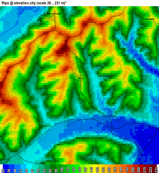
Below is the Elevation map of Ripe, which displays elevation range with different colors. Scale of the first map is from 28 to 231 m (92 to 758 ft) with average elevation of 104.8 meters (=344 ft) [note 1]
These maps also provides idea of topography and contour of this city, they are displayed at different zoom levels. More info about maps, scale and edge coordinates you can find below images.
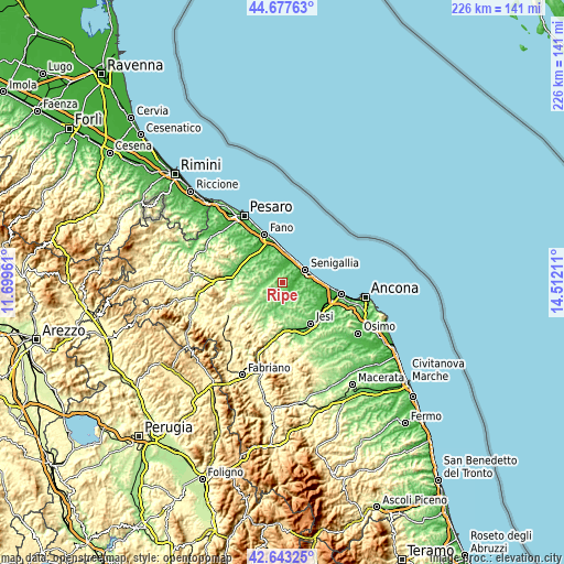
| \ | Map #1 | Topo.Map |
| Scale [m] | 28..231 m | × |
| Scale [ft] | 92..758 ft | × |
| Average | 104.8 m = 344 ft | × |
| Width | 7.07 km = 4.4 mi | 226.2 km = 140.6 mi |
| Height | 7.07 km = 4.4 mi | 226.2 km = 140.6 mi |
| ↑Max Latitude | 43.700839° | 44.67763° |
| Latitude at center | 43.66906° | 43.66906° |
| ↓Min Latitude | 43.637264° | 42.64325° |
| ← Min Longitude | 13.061915° | 11.69961° |
| Longitude center | 13.10586° | 13.10586° |
| →Max Longitude | 13.149805° | 14.51211° |
Nearby cities:
Cities around Ripe sort by population:
• Senigallia elevation 6 m
9.8 km,  57°
57°
• Mondolfo 68 m
8.5 km,  358°
358°
• Ostra 162 m
7.3 km,  144°
144°
• Corinaldo 127 m
4.8 km,  229°
229°
• Ostra Vetere 197 m
8.1 km,  206°
206°
• Passo Ripe 45 m
2 km, 138°
• Orciano di Pesaro 234 m
11 km,  281°
281°
• San Michele 104 m
8.7 km,  264°
264°
• Casine 59 m
5.2 km, 143°
• Monte Porzio 100 m
5.3 km,  297°
297°
• Pianello 45 m
5.2 km,  157°
157°
• Monterado 152 m
3.3 km,  338°
338°
Multilingual:
 En español:
Ripe elevación 137 m.
 En France:
Ripe élévation 137 m.


Sources and notes:
- [note 1] Map square and city borders are not equal. Map elevation data is calculated only from area inside that square.
- [src 1] Elevation data from geonames database provided with same terms of usage.
- [src 2] The elevation map of Ripe is generated using elevation data from NASA's 3 arcsec (90m) resolution SRTM data.
- [src 3] Base (background) map © OpenStreetMap contributors tiles are generated by Geofabrik and OpenTopoMap.
Copyright & License:
This Ripe Elevation Map is licensed under CC BY-SA. You may reuse any part from this page, if you give a proper credit by linking to this URL:
 More info on terms of use page.