Rivamonte Agordino elevation
Rivamonte Agordino (Veneto, Provincia di Belluno), Italy elevation is 973 meters and Rivamonte Agordino elevation in feet is 3192 ft above sea level [src 1]. Rivamonte Agordino is a seat of a third-order administrative division (feature code) with elevation that is 651 meters (2136 ft) bigger than average city elevation in Italy.
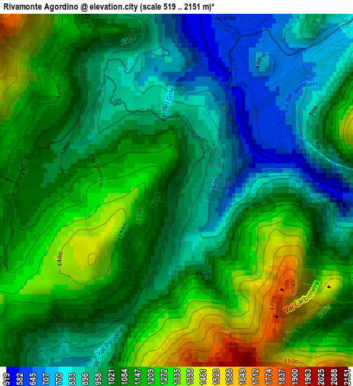
Below is the Elevation map of Rivamonte Agordino, which displays elevation range with different colors. Scale of the first map is from 519 to 2151 m (1703 to 7057 ft) with average elevation of 1077.2 meters (=3534 ft) [note 1]
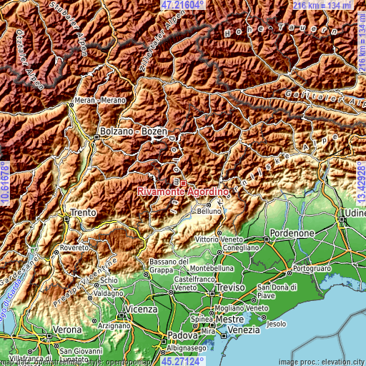
These maps also provides idea of topography and contour of this city, they are displayed at different zoom levels. More info about maps, scale and edge coordinates you can find below images.
| \ | Map #1 | Topo.Map |
| Scale [m] | 519..2151 m | × |
| Scale [ft] | 1703..7057 ft | × |
| Average | 1077.2 m = 3534 ft | × |
| Width | 6.76 km = 4.2 mi | 216.2 km = 134.3 mi |
| Height | 6.76 km = 4.2 mi | 216.2 km = 134.3 mi |
| ↑Max Latitude | 46.282639° | 47.21604° |
| Latitude at center | 46.25226° | 46.25226° |
| ↓Min Latitude | 46.221864° | 45.27124° |
| ← Min Longitude | 11.979085° | 10.61678° |
| Longitude center | 12.02303° | 12.02303° |
| →Max Longitude | 12.066975° | 13.42928° |
Nearby cities:
Cities around Rivamonte Agordino sort by population:
• Agordo elevation 619 m
3.5 km,  16°
16°
• Taibon Agordino 620 m
5.2 km,  351°
351°
• Cencenighe Agordino 767 m
11.8 km,  339°
339°
• Voltago Agordino 866 m
2.5 km,  328°
328°
• La Valle Agordina 811 m
4.8 km,  46°
46°
• Gosaldo 1143 m
6.2 km,  236°
236°
• Canale d'Agordo 986 m
14.3 km,  324°
324°
• Sospirolo 453 m
12.9 km,  162°
162°
• Vallada Agordina 965 m
14.2 km, 331°
• Voltago 852 m
2.6 km, 330°
• Don 1143 m
6.2 km, 236°
• Sagron Mis 1062 m
8.9 km,  223°
223°
Multilingual:
 En español:
Rivamonte Agordino elevación 973 m.
 En France:
Rivamonte Agordino élévation 973 m.
 Auf Deutsch:
Rivamonte Agordino höhe über dem Meeresspiegel ist 973 m.
 На русском:
Rivamonte Agordino высота над уровнем моря 973 м
Sources and notes:
- [note 1] Map square and city borders are not equal. Map elevation data is calculated only from area inside that square.
- [src 1] Elevation data from geonames database provided with same terms of usage.
- [src 2] The elevation map of Rivamonte Agordino is generated using elevation data from NASA's 3 arcsec (90m) resolution SRTM data.
- [src 3] Base (background) map © OpenStreetMap contributors tiles are generated by Geofabrik and OpenTopoMap.
Copyright & License:
This Rivamonte Agordino Elevation Map is licensed under CC BY-SA. You may reuse any part from this page, if you give a proper credit by linking to this URL:
 More info on terms of use page.