Rotondella elevation
Rotondella (Basilicate, Provincia di Matera), Italy elevation is 562 meters and Rotondella elevation in feet is 1844 ft above sea level [src 1]. Rotondella is a seat of a third-order administrative division (feature code) with elevation that is 240 meters (787 ft) bigger than average city elevation in Italy.
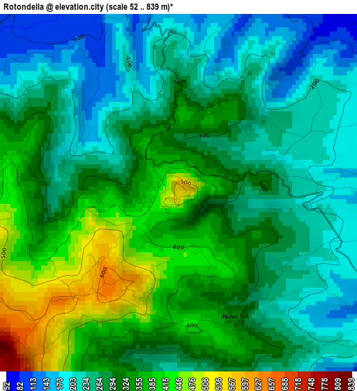
Below is the Elevation map of Rotondella, which displays elevation range with different colors. Scale of the first map is from 52 to 839 m (171 to 2753 ft) with average elevation of 295.9 meters (=971 ft) [note 1]
These maps also provides idea of topography and contour of this city, they are displayed at different zoom levels. More info about maps, scale and edge coordinates you can find below images.
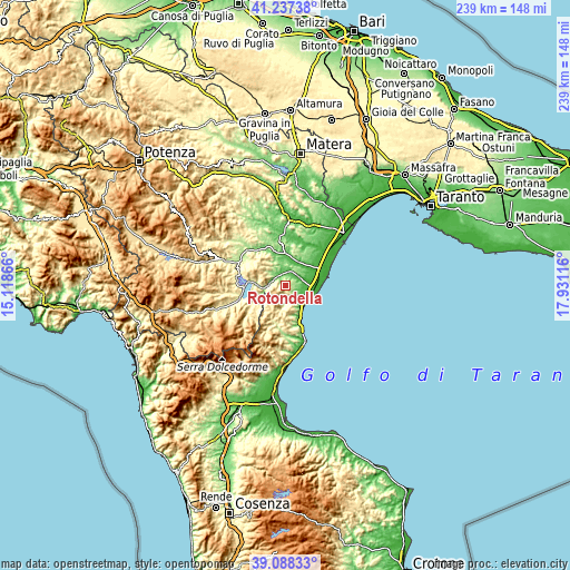
| \ | Map #1 | Topo.Map |
| Scale [m] | 52..839 m | × |
| Scale [ft] | 171..2753 ft | × |
| Average | 295.9 m = 971 ft | × |
| Width | 7.47 km = 4.6 mi | 239 km = 148.5 mi |
| Height | 7.47 km = 4.6 mi | 238.9 km = 148.4 mi |
| ↑Max Latitude | 40.204931° | 41.23738° |
| Latitude at center | 40.17136° | 40.17136° |
| ↓Min Latitude | 40.137772° | 39.08833° |
| ← Min Longitude | 16.480965° | 15.11866° |
| Longitude center | 16.52491° | 16.52491° |
| →Max Longitude | 16.568855° | 17.93116° |
Nearby cities:
Cities around Rotondella sort by population:
• Policoro elevation 25 m
13.8 km,  70°
70°
• Montalbano Jonico 248 m
13.3 km,  16°
16°
• Nova Siri Scalo 12 m
10.4 km,  115°
115°
• Tursi 188 m
9.5 km,  331°
331°
• Rocca Imperiale Marina 12 m
11 km,  136°
136°
• Valsinni 218 m
6.9 km,  269°
269°
• San Giorgio Lucano 366 m
13.3 km,  239°
239°
• Colobraro 618 m
8.7 km,  282°
282°
• Nova Siri 318 m
2.9 km,  153°
153°
• Rocca Imperiale 175 m
8.2 km, 146°
• Canna 403 m
8.7 km,  191°
191°
• Nocara 851 m
8.8 km,  204°
204°
Multilingual:
 En español:
Rotondella elevación 562 m.
 En France:
Rotondella élévation 562 m.
 Auf Deutsch:
Rotondella höhe über dem Meeresspiegel ist 562 m.

Sources and notes:
- [note 1] Map square and city borders are not equal. Map elevation data is calculated only from area inside that square.
- [src 1] Elevation data from geonames database provided with same terms of usage.
- [src 2] The elevation map of Rotondella is generated using elevation data from NASA's 3 arcsec (90m) resolution SRTM data.
- [src 3] Base (background) map © OpenStreetMap contributors tiles are generated by Geofabrik and OpenTopoMap.
Copyright & License:
This Rotondella Elevation Map is licensed under CC BY-SA. You may reuse any part from this page, if you give a proper credit by linking to this URL:
 More info on terms of use page.