Rozzano elevation
Rozzano (Lombardy, Città metropolitana di Milano), Italy elevation is 110 meters and Rozzano elevation in feet is 361 ft above sea level [src 1]. Rozzano is a seat of a third-order administrative division (feature code) with elevation that is 212 meters (696 ft) smaller than average city elevation in Italy.
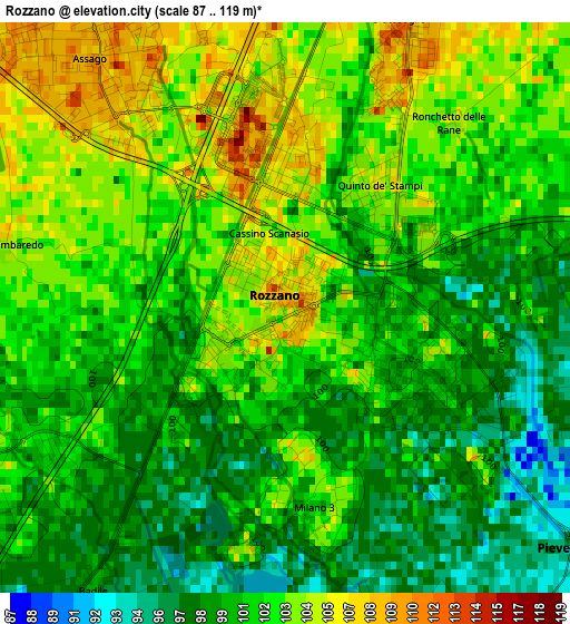
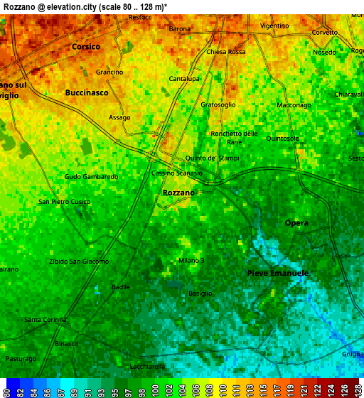
Below is the Elevation map of Rozzano, which displays elevation range with different colors. Scale of the first map is from 87 to 119 m (285 to 390 ft) with average elevation of 101.3 meters (=332 ft) [note 1]
These maps also provides idea of topography and contour of this city, they are displayed at different zoom levels. More info about maps, scale and edge coordinates you can find below images.
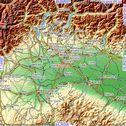
| \ | Map #1 | Map #2 | Topo.Map |
| Scale [m] | 87..119 m | 80..128 m | × |
| Scale [ft] | 285..390 ft | 262..420 ft | × |
| Average | 101.3 m = 332 ft | 102 m = 335 ft | × |
| Width | 6.86 km = 4.3 mi | 13.73 km = 8.5 mi | 219.6 km = 136.5 mi |
| Height | 6.86 km = 4.3 mi | 13.73 km = 8.5 mi | 219.6 km = 136.5 mi |
| ↑Max Latitude | 45.412788° | 45.443629° | 46.36102° |
| Latitude at center | 45.38193° | 45.38193° | 45.38193° |
| ↓Min Latitude | 45.351055° | 45.320164° | 44.38558° |
| ← Min Longitude | 9.111955° | 9.068009° | 7.74965° |
| Longitude center | 9.1559° | 9.1559° | 9.1559° |
| →Max Longitude | 9.199845° | 9.243791° | 10.56215° |
Nearby cities:
Cities around Rozzano sort by population:
• Romano Banco elevation 116 m
6 km,  320°
320°
• Pieve Emanuele 98 m
5.1 km,  133°
133°
• Opera 106 m
4.4 km,  102°
102°
• Locate di Triulzi 97 m
6.1 km,  117°
117°
• Assago 107 m
3.8 km, 321°
• Basiglio 100 m
2.5 km,  175°
175°
• Zibido San Giacomo 100 m
4.2 km,  235°
235°
• Fizzonasco 93 m
2.9 km,  111°
111°
• Poasco-Sorigherio 103 m
6.3 km,  68°
68°
• Noverasco-Sporting Mirasole 111 m
4.8 km, 71°
• Badile 98 m
4.1 km,  212°
212°
• Buccinasco 111 m
4.6 km,  306°
306°
Multilingual:
 En español:
Rozzano elevación 110 m.
 En France:
Rozzano élévation 110 m.


Sources and notes:
- [note 1] Map square and city borders are not equal. Map elevation data is calculated only from area inside that square.
- [src 1] Elevation data from geonames database provided with same terms of usage.
- [src 2] The elevation map of Rozzano is generated using elevation data from NASA's 3 arcsec (90m) resolution SRTM data.
- [src 3] Base (background) map © OpenStreetMap contributors tiles are generated by Geofabrik and OpenTopoMap.
Copyright & License:
This Rozzano Elevation Map is licensed under CC BY-SA. You may reuse any part from this page, if you give a proper credit by linking to this URL:
 More info on terms of use page.