Salice Terme elevation
Salice Terme (Lombardy, Provincia di Pavia), Italy elevation is 174 meters and Salice Terme elevation in feet is 571 ft above sea level [src 1]. Salice Terme is a populated place (feature code) with elevation that is 148 meters (486 ft) smaller than average city elevation in Italy.
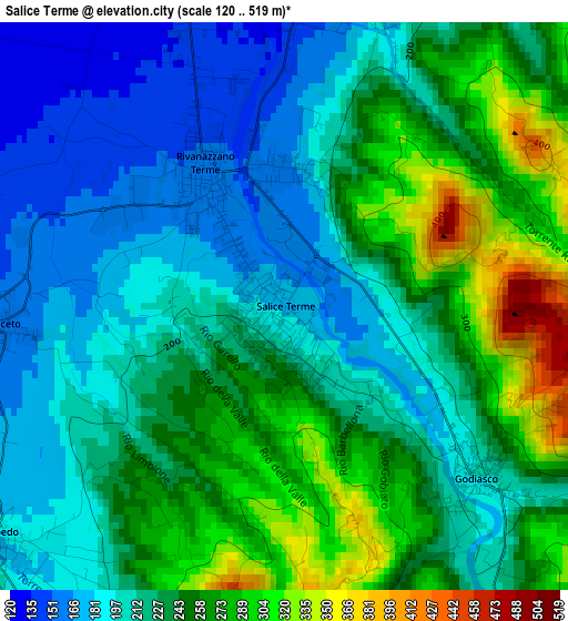
Below is the Elevation map of Salice Terme, which displays elevation range with different colors. Scale of the first map is from 120 to 519 m (394 to 1703 ft) with average elevation of 230.8 meters (=757 ft) [note 1]
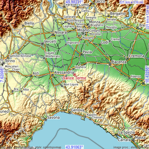
These maps also provides idea of topography and contour of this city, they are displayed at different zoom levels. More info about maps, scale and edge coordinates you can find below images.
| \ | Map #1 | Topo.Map |
| Scale [m] | 120..519 m | × |
| Scale [ft] | 394..1703 ft | × |
| Average | 230.8 m = 757 ft | × |
| Width | 6.92 km = 4.3 mi | 221.5 km = 137.6 mi |
| Height | 6.92 km = 4.3 mi | 221.4 km = 137.6 mi |
| ↑Max Latitude | 44.946212° | 45.90231° |
| Latitude at center | 44.9151° | 44.9151° |
| ↓Min Latitude | 44.883972° | 43.91063° |
| ← Min Longitude | 8.982355° | 7.62005° |
| Longitude center | 9.0263° | 9.0263° |
| →Max Longitude | 9.070245° | 10.43255° |
Nearby cities:
Cities around Salice Terme sort by population:
• Rivanazzano elevation 155 m
1.8 km,  327°
327°
• Retorbido 161 m
3.9 km,  12°
12°
• Godiasco 201 m
3.2 km,  130°
130°
• Volpedo 187 m
4.3 km,  227°
227°
• Casalnoceto 162 m
3.4 km,  266°
266°
• Codevilla 149 m
5.9 km,  24°
24°
• Pozzol Groppo 366 m
4.1 km,  176°
176°
• Castellar Guidobono 150 m
6.2 km,  259°
259°
• Monleale 297 m
5.4 km, 230°
• Volpeglino 229 m
5.8 km,  244°
244°
• Berzano di Tortona 285 m
7.3 km, 234°
• Susella 500 m
5.5 km,  92°
92°
Multilingual:
 En español:
Salice Terme elevación 174 m.
 En France:
Salice Terme élévation 174 m.
 Auf Deutsch:
Salice Terme höhe über dem Meeresspiegel ist 174 m.

Sources and notes:
- [note 1] Map square and city borders are not equal. Map elevation data is calculated only from area inside that square.
- [src 1] Elevation data from geonames database provided with same terms of usage.
- [src 2] The elevation map of Salice Terme is generated using elevation data from NASA's 3 arcsec (90m) resolution SRTM data.
- [src 3] Base (background) map © OpenStreetMap contributors tiles are generated by Geofabrik and OpenTopoMap.
Copyright & License:
This Salice Terme Elevation Map is licensed under CC BY-SA. You may reuse any part from this page, if you give a proper credit by linking to this URL:
 More info on terms of use page.