Salvaterra elevation
Salvaterra (Emilia-Romagna, Provincia di Reggio Emilia), Italy elevation is 76 meters and Salvaterra elevation in feet is 249 ft above sea level [src 1]. Salvaterra is a populated place (feature code) with elevation that is 246 meters (807 ft) smaller than average city elevation in Italy.
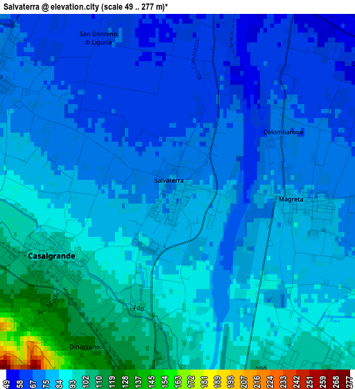
Below is the Elevation map of Salvaterra, which displays elevation range with different colors. Scale of the first map is from 49 to 277 m (161 to 909 ft) with average elevation of 80.8 meters (=265 ft) [note 1]
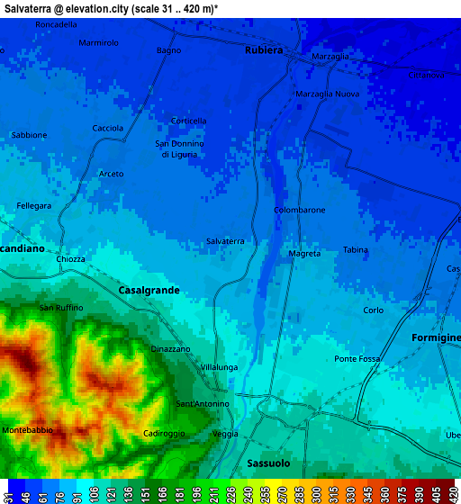
These maps also provides idea of topography and contour of this city, they are displayed at different zoom levels. More info about maps, scale and edge coordinates you can find below images.
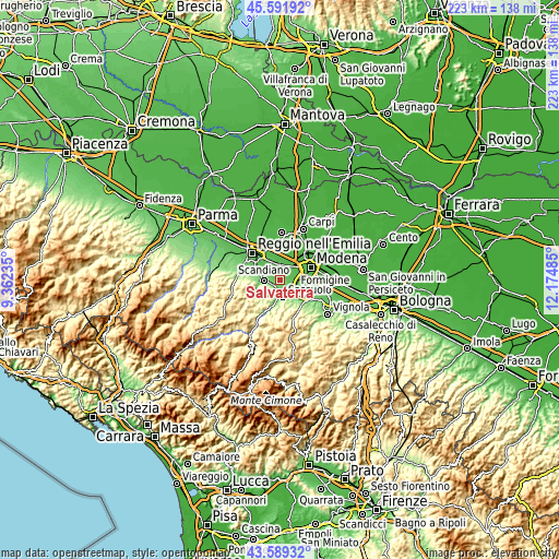
| \ | Map #1 | Map #2 | Topo.Map |
| Scale [m] | 49..277 m | 31..420 m | × |
| Scale [ft] | 161..909 ft | 102..1378 ft | × |
| Average | 80.8 m = 265 ft | 99.5 m = 326 ft | × |
| Width | 6.96 km = 4.3 mi | 13.92 km = 8.6 mi | 222.7 km = 138.4 mi |
| Height | 6.96 km = 4.3 mi | 13.92 km = 8.6 mi | 222.7 km = 138.4 mi |
| ↑Max Latitude | 44.630532° | 44.661798° | 45.59192° |
| Latitude at center | 44.59925° | 44.59925° | 44.59925° |
| ↓Min Latitude | 44.567951° | 44.536635° | 43.58932° |
| ← Min Longitude | 10.724655° | 10.680709° | 9.36235° |
| Longitude center | 10.7686° | 10.7686° | 10.7686° |
| →Max Longitude | 10.812545° | 10.856491° | 12.17485° |
Nearby cities:
Cities around Salvaterra sort by population:
• Sassuolo elevation 123 m
6.4 km,  168°
168°
• Formigine 82 m
6.9 km,  115°
115°
• Rubiera 53 m
5.9 km,  8°
8°
• Scandiano 95 m
5.8 km,  268°
268°
• Casalgrande 108 m
3.1 km,  238°
238°
• Veggia-Villalunga 132 m
4.4 km,  192°
192°
• Arceto 75 m
4 km,  300°
300°
• Magreta 77 m
2.5 km,  88°
88°
• Baggiovara 61 m
7.5 km, 85°
• Ventoso 138 m
6.6 km,  257°
257°
• Bagno 52 m
6.3 km,  352°
352°
• Fellegara 83 m
5.8 km,  282°
282°
Multilingual:
 En español:
Salvaterra elevación 76 m.
 En France:
Salvaterra élévation 76 m.
 Auf Deutsch:
Salvaterra höhe über dem Meeresspiegel ist 76 m.

Sources and notes:
- [note 1] Map square and city borders are not equal. Map elevation data is calculated only from area inside that square.
- [src 1] Elevation data from geonames database provided with same terms of usage.
- [src 2] The elevation map of Salvaterra is generated using elevation data from NASA's 3 arcsec (90m) resolution SRTM data.
- [src 3] Base (background) map © OpenStreetMap contributors tiles are generated by Geofabrik and OpenTopoMap.
Copyright & License:
This Salvaterra Elevation Map is licensed under CC BY-SA. You may reuse any part from this page, if you give a proper credit by linking to this URL:
 More info on terms of use page.