San Nazario elevation
San Nazario (Veneto, Provincia di Vicenza), Italy elevation is 156 meters and San Nazario elevation in feet is 512 ft above sea level [src 1]. San Nazario is a seat of a third-order administrative division (feature code) with elevation that is 166 meters (545 ft) smaller than average city elevation in Italy.
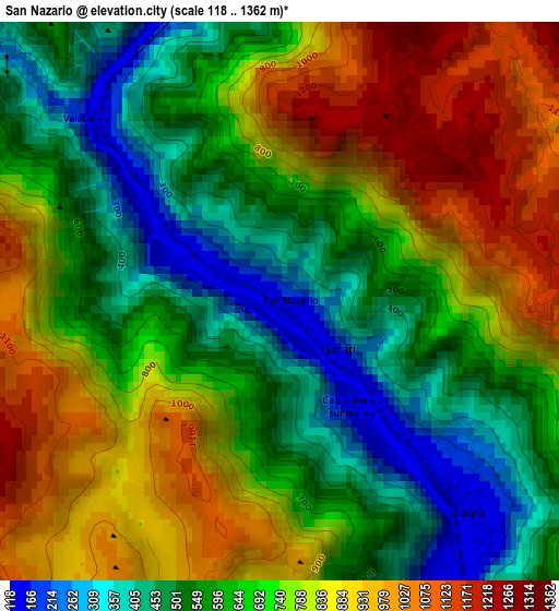
Below is the Elevation map of San Nazario, which displays elevation range with different colors. Scale of the first map is from 118 to 1362 m (387 to 4469 ft) with average elevation of 698.3 meters (=2291 ft) [note 1]
These maps also provides idea of topography and contour of this city, they are displayed at different zoom levels. More info about maps, scale and edge coordinates you can find below images.
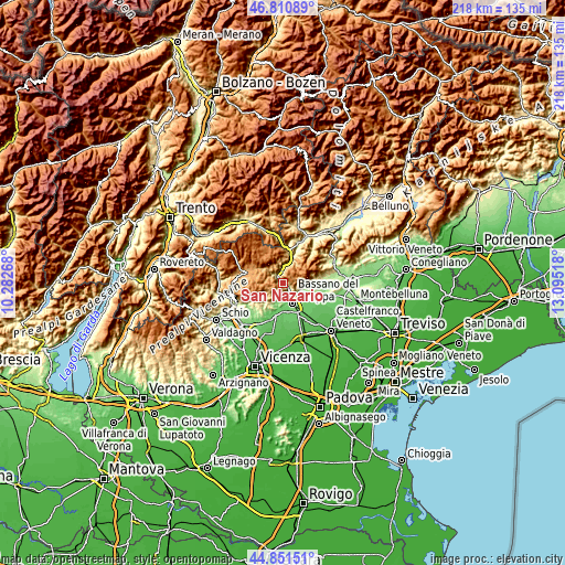
| \ | Map #1 | Topo.Map |
| Scale [m] | 118..1362 m | × |
| Scale [ft] | 387..4469 ft | × |
| Average | 698.3 m = 2291 ft | × |
| Width | 6.81 km = 4.2 mi | 217.9 km = 135.4 mi |
| Height | 6.81 km = 4.2 mi | 217.9 km = 135.4 mi |
| ↑Max Latitude | 45.870427° | 46.81089° |
| Latitude at center | 45.83982° | 45.83982° |
| ↓Min Latitude | 45.809196° | 44.85151° |
| ← Min Longitude | 11.644985° | 10.28268° |
| Longitude center | 11.68893° | 11.68893° |
| →Max Longitude | 11.732875° | 13.09518° |
Nearby cities:
Cities around San Nazario sort by population:
• Bassano del Grappa elevation 112 m
8.7 km,  159°
159°
• Romano d'Ezzelino 130 m
9.1 km,  138°
138°
• Marostica 100 m
10.7 km,  191°
191°
• Borso del Grappa 185 m
7.3 km,  116°
116°
• Pove del Grappa 161 m
5.6 km,  145°
145°
• Solagna 135 m
3.2 km, 135°
• Campese 132 m
4.2 km, 153°
• Valstagna 147 m
2.1 km,  305°
305°
• Conco 842 m
7.5 km,  234°
234°
• Campolongo sul Brenta 141 m
1.7 km, 146°
• Cismon del Grappa 206 m
9.4 km,  18°
18°
• Foza 1084 m
7.8 km,  324°
324°
Multilingual:
 En español:
San Nazario elevación 156 m.
 En France:
San Nazario élévation 156 m.
 Auf Deutsch:
San Nazario höhe über dem Meeresspiegel ist 156 m.

Sources and notes:
- [note 1] Map square and city borders are not equal. Map elevation data is calculated only from area inside that square.
- [src 1] Elevation data from geonames database provided with same terms of usage.
- [src 2] The elevation map of San Nazario is generated using elevation data from NASA's 3 arcsec (90m) resolution SRTM data.
- [src 3] Base (background) map © OpenStreetMap contributors tiles are generated by Geofabrik and OpenTopoMap.
Copyright & License:
This San Nazario Elevation Map is licensed under CC BY-SA. You may reuse any part from this page, if you give a proper credit by linking to this URL:
 More info on terms of use page.