San Sebastiano elevation
San Sebastiano (Lombardy, Provincia di Brescia), Italy elevation is 476 meters and San Sebastiano elevation in feet is 1562 ft above sea level [src 1]. San Sebastiano is a seat of a third-order administrative division (feature code) with elevation that is 154 meters (505 ft) bigger than average city elevation in Italy.
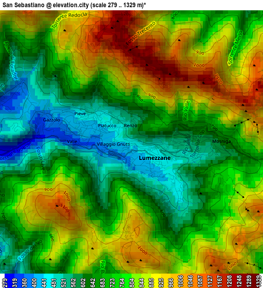
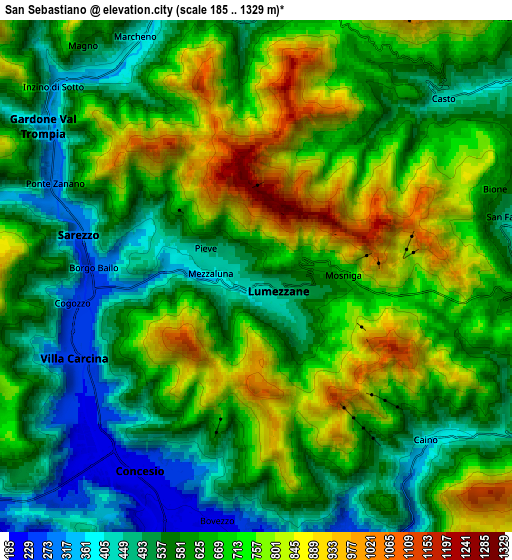
Below is the Elevation map of San Sebastiano, which displays elevation range with different colors. Scale of the first map is from 279 to 1329 m (915 to 4360 ft) with average elevation of 769.2 meters (=2524 ft) [note 1]
These maps also provides idea of topography and contour of this city, they are displayed at different zoom levels. More info about maps, scale and edge coordinates you can find below images.
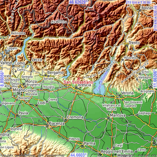
| \ | Map #1 | Map #2 | Topo.Map |
| Scale [m] | 279..1329 m | 185..1329 m | × |
| Scale [ft] | 915..4360 ft | 607..4360 ft | × |
| Average | 769.2 m = 2524 ft | 644.3 m = 2114 ft | × |
| Width | 6.83 km = 4.2 mi | 13.66 km = 8.5 mi | 218.6 km = 135.8 mi |
| Height | 6.83 km = 4.2 mi | 13.66 km = 8.5 mi | 218.6 km = 135.8 mi |
| ↑Max Latitude | 45.68263° | 45.713323° | 46.62629° |
| Latitude at center | 45.65192° | 45.65192° | 45.65192° |
| ↓Min Latitude | 45.621193° | 45.590449° | 44.6603° |
| ← Min Longitude | 10.212865° | 10.168919° | 8.85056° |
| Longitude center | 10.25681° | 10.25681° | 10.25681° |
| →Max Longitude | 10.300755° | 10.344701° | 11.66306° |
Nearby cities:
Cities around San Sebastiano sort by population:
• Lumezzane elevation 467 m
0.8 km,  125°
125°
• Sarezzo 275 m
4.8 km,  281°
281°
• Concesio 213 m
6.1 km,  210°
210°
• Villa Carcina 242 m
5.2 km,  246°
246°
• Gardone Val Trompia 324 m
7 km,  308°
308°
• Bovezzo 191 m
7 km,  189°
189°
• San Vigilio 220 m
6.9 km,  224°
224°
• Marcheno 372 m
6.9 km,  331°
331°
• Caino 341 m
6.4 km,  137°
137°
• Bione 609 m
6.8 km,  70°
70°
• Agnosine 470 m
7.5 km,  91°
91°
• Casto 425 m
6.9 km,  46°
46°
Multilingual:
 En español:
San Sebastiano elevación 476 m.
 En France:
San Sebastiano élévation 476 m.
 Auf Deutsch:
San Sebastiano höhe über dem Meeresspiegel ist 476 m.

Sources and notes:
- [note 1] Map square and city borders are not equal. Map elevation data is calculated only from area inside that square.
- [src 1] Elevation data from geonames database provided with same terms of usage.
- [src 2] The elevation map of San Sebastiano is generated using elevation data from NASA's 3 arcsec (90m) resolution SRTM data.
- [src 3] Base (background) map © OpenStreetMap contributors tiles are generated by Geofabrik and OpenTopoMap.
Copyright & License:
This San Sebastiano Elevation Map is licensed under CC BY-SA. You may reuse any part from this page, if you give a proper credit by linking to this URL:
 More info on terms of use page.