Santa Margherita Ligure elevation
Santa Margherita Ligure (Liguria, Provincia di Genova), Italy elevation is 9 meters and Santa Margherita Ligure elevation in feet is 30 ft above sea level [src 1]. Santa Margherita Ligure is a seat of a third-order administrative division (feature code) with elevation that is 313 meters (1027 ft) smaller than average city elevation in Italy.
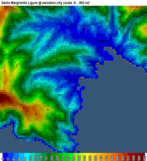
Below is the Elevation map of Santa Margherita Ligure, which displays elevation range with different colors. Scale of the first map is from -6 to 603 m (-20 to 1978 ft) with average elevation of 153.7 meters (=504 ft) [note 1]
These maps also provides idea of topography and contour of this city, they are displayed at different zoom levels. More info about maps, scale and edge coordinates you can find below images.
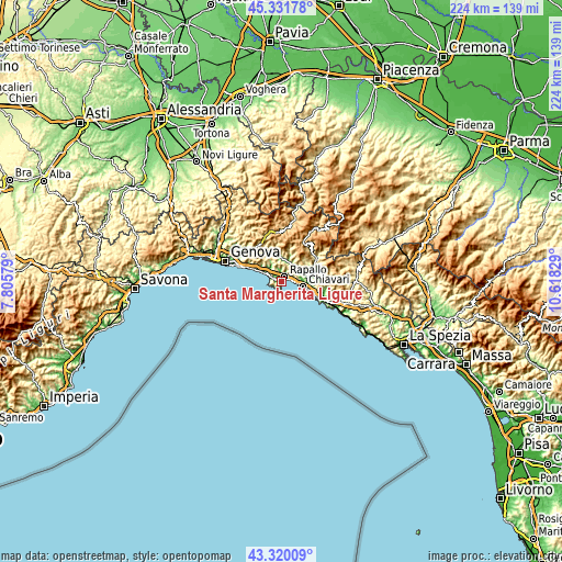
| \ | Map #1 | Map #2 | Topo.Map |
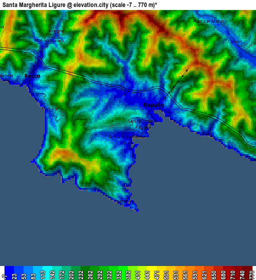
| Scale [m] | -6..603 m | -7..770 m | × |
| Scale [ft] | -20..1978 ft | -23..2526 ft | × |
| Average | 153.7 m = 504 ft | 248.2 m = 814 ft | × |
| Width | 6.99 km = 4.3 mi | 13.98 km = 8.7 mi | 223.7 km = 139 mi |
| Height | 6.99 km = 4.3 mi | 13.98 km = 8.7 mi | 223.7 km = 139 mi |
| ↑Max Latitude | 44.365984° | 44.397392° | 45.33178° |
| Latitude at center | 44.33456° | 44.33456° | 44.33456° |
| ↓Min Latitude | 44.303119° | 44.271661° | 43.32009° |
| ← Min Longitude | 9.168095° | 9.124149° | 7.80579° |
| Longitude center | 9.21204° | 9.21204° | 9.21204° |
| →Max Longitude | 9.255985° | 9.299931° | 10.61829° |
Nearby cities:
Cities around Santa Margherita Ligure sort by population:
• Rapallo elevation 11 m
2.1 km,  37°
37°
• Chiavari 7 m
9 km,  102°
102°
• Recco 11 m
6.3 km,  299°
299°
• Camogli 35 m
4.8 km,  290°
290°
• Leivi 234 m
8.1 km,  75°
75°
• Avegno 58 m
6.9 km,  321°
321°
• Zoagli 14 m
4.4 km,  86°
86°
• Cicagna 85 m
8.4 km,  14°
14°
• Portofino 11 m
3.5 km,  183°
183°
• Chiesa Nuova 38 m
8.8 km,  63°
63°
• Bocco 209 m
7.5 km, 75°
• Coreglia Ligure 297 m
7.1 km,  33°
33°
Multilingual:
 En español:
Santa Margherita Ligure elevación 9 m.
 En France:
Santa Margherita Ligure élévation 9 m.
 Auf Deutsch:
Santa Margherita Ligure höhe über dem Meeresspiegel ist 9 m.
 На русском:
Санта-Маргарита Лигурэ высота над уровнем моря 9 м
Sources and notes:
- [note 1] Map square and city borders are not equal. Map elevation data is calculated only from area inside that square.
- [src 1] Elevation data from geonames database provided with same terms of usage.
- [src 2] The elevation map of Santa Margherita Ligure is generated using elevation data from NASA's 3 arcsec (90m) resolution SRTM data.
- [src 3] Base (background) map © OpenStreetMap contributors tiles are generated by Geofabrik and OpenTopoMap.
Copyright & License:
This Santa Margherita Ligure Elevation Map is licensed under CC BY-SA. You may reuse any part from this page, if you give a proper credit by linking to this URL:
 More info on terms of use page.