Sant'Anastasia elevation
Sant'Anastasia (Campania, Napoli), Italy elevation is 147 meters and Sant'Anastasia elevation in feet is 482 ft above sea level [src 1]. Sant'Anastasia is a seat of a third-order administrative division (feature code) with elevation that is 175 meters (574 ft) smaller than average city elevation in Italy.
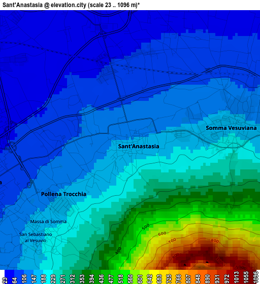
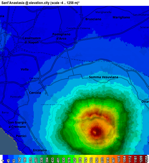
Below is the Elevation map of Sant'Anastasia, which displays elevation range with different colors. Scale of the first map is from 23 to 1096 m (75 to 3596 ft) with average elevation of 206.2 meters (=677 ft) [note 1]
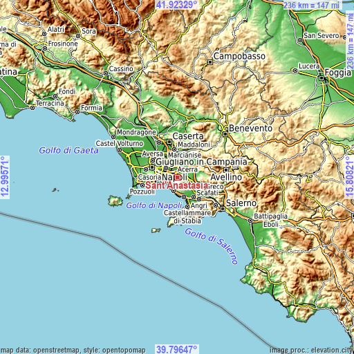
These maps also provides idea of topography and contour of this city, they are displayed at different zoom levels. More info about maps, scale and edge coordinates you can find below images.
| \ | Map #1 | Map #2 | Topo.Map |
| Scale [m] | 23..1096 m | -4..1258 m | × |
| Scale [ft] | 75..3596 ft | -13..4127 ft | × |
| Average | 206.2 m = 677 ft | 177.7 m = 583 ft | × |
| Width | 7.39 km = 4.6 mi | 14.78 km = 9.2 mi | 236.5 km = 147 mi |
| Height | 7.39 km = 4.6 mi | 14.78 km = 9.2 mi | 236.5 km = 147 mi |
| ↑Max Latitude | 40.901644° | 40.934851° | 41.92329° |
| Latitude at center | 40.86842° | 40.86842° | 40.86842° |
| ↓Min Latitude | 40.83518° | 40.801923° | 39.79647° |
| ← Min Longitude | 14.358015° | 14.314069° | 12.99571° |
| Longitude center | 14.40196° | 14.40196° | 14.40196° |
| →Max Longitude | 14.445905° | 14.489851° | 15.80821° |
Nearby cities:
Cities around Sant'Anastasia sort by population:
• Ponticelli elevation 28 m
6.2 km,  255°
255°
• Pomigliano d'Arco 32 m
4.9 km,  341°
341°
• Somma Vesuviana 155 m
3.1 km,  80°
80°
• Volla 26 m
5.2 km,  276°
276°
• Cercola 70 m
3.9 km, 256°
• Pollena Trocchia 168 m
2.7 km,  225°
225°
• San Sebastiano al Vesuvio 142 m
4.2 km, 228°
• Castello di Cisterna 40 m
5.3 km,  8°
8°
• Massa di Somma 187 m
3.4 km,  221°
221°
• Starza Vecchia 63 m
2.4 km,  358°
358°
• Casarea 36 m
3.9 km,  304°
304°
• Musci 52 m
3.2 km,  290°
290°
Multilingual:
 En español:
Sant'Anastasia elevación 147 m.
 En France:
Sant'Anastasia élévation 147 m.
 Auf Deutsch:
Sant'Anastasia höhe über dem Meeresspiegel ist 147 m.

Sources and notes:
- [note 1] Map square and city borders are not equal. Map elevation data is calculated only from area inside that square.
- [src 1] Elevation data from geonames database provided with same terms of usage.
- [src 2] The elevation map of Sant'Anastasia is generated using elevation data from NASA's 3 arcsec (90m) resolution SRTM data.
- [src 3] Base (background) map © OpenStreetMap contributors tiles are generated by Geofabrik and OpenTopoMap.
Copyright & License:
This Sant'Anastasia Elevation Map is licensed under CC BY-SA. You may reuse any part from this page, if you give a proper credit by linking to this URL:
 More info on terms of use page.