Celat-San Tomaso Agordino elevation
Celat-San Tomaso Agordino (Veneto, Provincia di Belluno), Italy elevation is 1100 meters and Celat-San Tomaso Agordino elevation in feet is 3609 ft above sea level [src 1]. Celat-San Tomaso Agordino is a seat of a third-order administrative division (feature code) with elevation that is 778 meters (2552 ft) bigger than average city elevation in Italy.
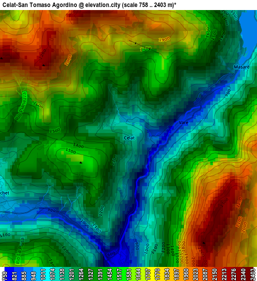
Below is the Elevation map of Celat-San Tomaso Agordino, which displays elevation range with different colors. Scale of the first map is from 758 to 2403 m (2487 to 7884 ft) with average elevation of 1432.1 meters (=4698 ft) [note 1]
These maps also provides idea of topography and contour of this city, they are displayed at different zoom levels. More info about maps, scale and edge coordinates you can find below images.
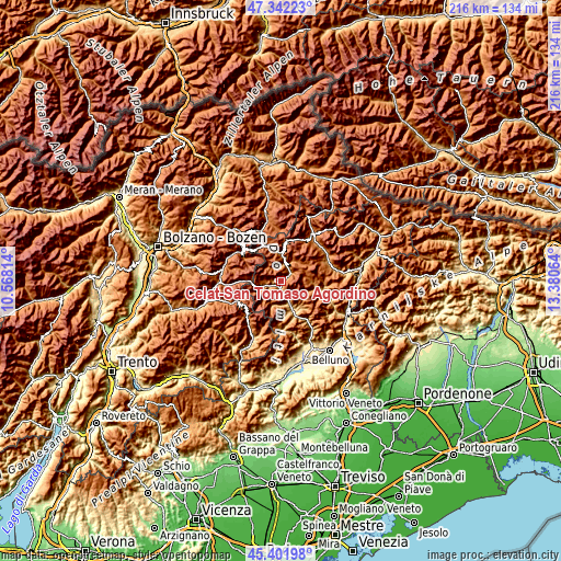
| \ | Map #1 | Topo.Map |
| Scale [m] | 758..2403 m | × |
| Scale [ft] | 2487..7884 ft | × |
| Average | 1432.1 m = 4698 ft | × |
| Width | 6.74 km = 4.2 mi | 215.7 km = 134 mi |
| Height | 6.74 km = 4.2 mi | 215.7 km = 134 mi |
| ↑Max Latitude | 46.411028° | 47.34223° |
| Latitude at center | 46.38072° | 46.38072° |
| ↓Min Latitude | 46.350395° | 45.40198° |
| ← Min Longitude | 11.930445° | 10.56814° |
| Longitude center | 11.97439° | 11.97439° |
| →Max Longitude | 12.018335° | 13.38064° |
Nearby cities:
Cities around Celat-San Tomaso Agordino sort by population:
• Taibon Agordino elevation 620 m
9.6 km,  162°
162°
• Livinallongo del Col di Lana 1474 m
11.3 km,  352°
352°
• Cencenighe Agordino 767 m
3.2 km,  188°
188°
• Pie' Falcade 1148 m
8.3 km,  251°
251°
• Canale d'Agordo 986 m
5.3 km,  240°
240°
• Alleghe 1029 m
4.8 km,  51°
51°
• Selva di Cadore 1505 m
10 km,  39°
39°
• Vallada Agordina 965 m
3.6 km, 239°
• Sachet 1072 m
3.5 km, 249°
• Colle Santa Lucia 1432 m
8.1 km,  21°
21°
• Rocca Pietore 1150 m
5.9 km,  1°
1°
• Falcade Alto 1336 m
9.4 km, 252°
Multilingual:
 En español:
Celat-San Tomaso Agordino elevación 1100 m.
 En France:
Celat-San Tomaso Agordino élévation 1100 m.
 Auf Deutsch:
Celat-San Tomaso Agordino höhe über dem Meeresspiegel ist 1100 m.
 На русском:
Celat-San Tomaso Agordino высота над уровнем моря 1100 м
Sources and notes:
- [note 1] Map square and city borders are not equal. Map elevation data is calculated only from area inside that square.
- [src 1] Elevation data from geonames database provided with same terms of usage.
- [src 2] The elevation map of Celat-San Tomaso Agordino is generated using elevation data from NASA's 3 arcsec (90m) resolution SRTM data.
- [src 3] Base (background) map © OpenStreetMap contributors tiles are generated by Geofabrik and OpenTopoMap.
Copyright & License:
This Celat-San Tomaso Agordino Elevation Map is licensed under CC BY-SA. You may reuse any part from this page, if you give a proper credit by linking to this URL:
 More info on terms of use page.