Sant'Oreste elevation
Sant'Oreste (Latium, Città metropolitana di Roma Capitale), Italy elevation is 307 meters and Sant'Oreste elevation in feet is 1007 ft above sea level [src 1]. Sant'Oreste is a seat of a third-order administrative division (feature code) with elevation that is 15 meters (49 ft) smaller than average city elevation in Italy.
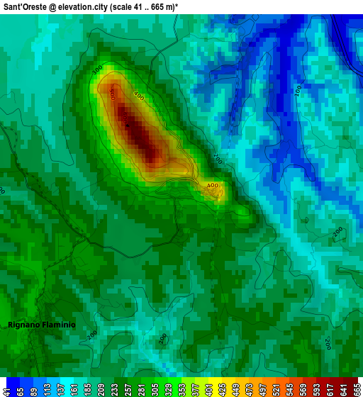
Below is the Elevation map of Sant'Oreste, which displays elevation range with different colors. Scale of the first map is from 41 to 665 m (135 to 2182 ft) with average elevation of 212.7 meters (=698 ft) [note 1]
These maps also provides idea of topography and contour of this city, they are displayed at different zoom levels. More info about maps, scale and edge coordinates you can find below images.
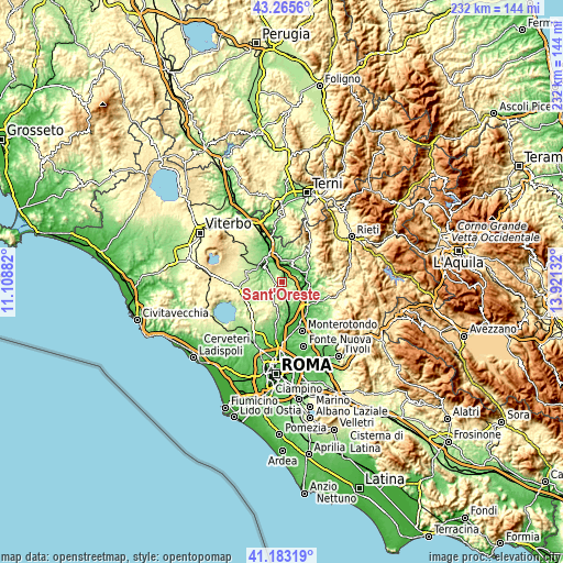
| \ | Map #1 | Topo.Map |
| Scale [m] | 41..665 m | × |
| Scale [ft] | 135..2182 ft | × |
| Average | 212.7 m = 698 ft | × |
| Width | 7.24 km = 4.5 mi | 231.5 km = 143.8 mi |
| Height | 7.24 km = 4.5 mi | 231.5 km = 143.8 mi |
| ↑Max Latitude | 42.26551° | 43.2656° |
| Latitude at center | 42.23298° | 42.23298° |
| ↓Min Latitude | 42.200434° | 41.18319° |
| ← Min Longitude | 12.471125° | 11.10882° |
| Longitude center | 12.51507° | 12.51507° |
| →Max Longitude | 12.559015° | 13.92132° |
Nearby cities:
Cities around Sant'Oreste sort by population:
• Rignano Flaminio elevation 251 m
4.2 km,  222°
222°
• Morlupo 231 m
9.3 km,  186°
186°
• Faleria 211 m
5.8 km,  262°
262°
• Forano 214 m
9.7 km,  42°
42°
• Montelarco 249 m
8.2 km,  198°
198°
• Civitella San Paolo 221 m
6.2 km,  127°
127°
• Nazzano 188 m
6.5 km,  92°
92°
• Stimigliano 209 m
8.5 km,  27°
27°
• Ponzano Romano 180 m
5.3 km,  59°
59°
• Calcata Nuova 220 m
7.5 km, 258°
• Torrita Tiberina 206 m
8.4 km, 86°
• Filacciano 165 m
7.3 km,  70°
70°
Multilingual:
 En español:
Sant'Oreste elevación 307 m.
 En France:
Sant'Oreste élévation 307 m.
 Auf Deutsch:
Sant'Oreste höhe über dem Meeresspiegel ist 307 m.

Sources and notes:
- [note 1] Map square and city borders are not equal. Map elevation data is calculated only from area inside that square.
- [src 1] Elevation data from geonames database provided with same terms of usage.
- [src 2] The elevation map of Sant'Oreste is generated using elevation data from NASA's 3 arcsec (90m) resolution SRTM data.
- [src 3] Base (background) map © OpenStreetMap contributors tiles are generated by Geofabrik and OpenTopoMap.
Copyright & License:
This Sant'Oreste Elevation Map is licensed under CC BY-SA. You may reuse any part from this page, if you give a proper credit by linking to this URL:
 More info on terms of use page.