San Vito al Tagliamento elevation
San Vito al Tagliamento (Friuli Venezia Giulia, Provincia di Pordenone), Italy elevation is 32 meters and San Vito al Tagliamento elevation in feet is 105 ft above sea level [src 1]. San Vito al Tagliamento is a seat of a third-order administrative division (feature code) with elevation that is 290 meters (951 ft) smaller than average city elevation in Italy.
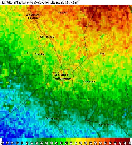
Below is the Elevation map of San Vito al Tagliamento, which displays elevation range with different colors. Scale of the first map is from 15 to 43 m (49 to 141 ft) with average elevation of 28 meters (=92 ft) [note 1]
These maps also provides idea of topography and contour of this city, they are displayed at different zoom levels. More info about maps, scale and edge coordinates you can find below images.
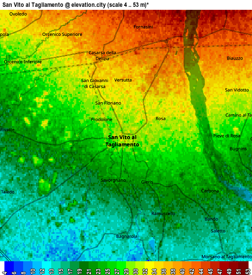
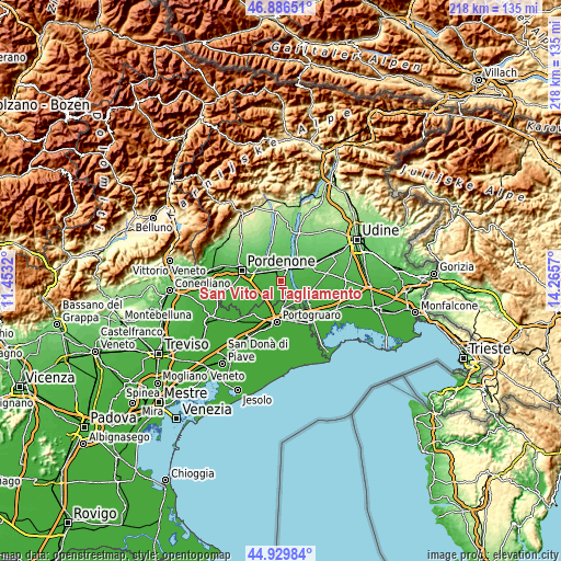
| \ | Map #1 | Map #2 | Topo.Map |
| Scale [m] | 15..43 m | 4..53 m | × |
| Scale [ft] | 49..141 ft | 13..174 ft | × |
| Average | 28 m = 92 ft | 26.8 m = 88 ft | × |
| Width | 6.8 km = 4.2 mi | 13.6 km = 8.5 mi | 217.6 km = 135.2 mi |
| Height | 6.8 km = 4.2 mi | 13.6 km = 8.5 mi | 217.5 km = 135.1 mi |
| ↑Max Latitude | 45.947364° | 45.977912° | 46.88651° |
| Latitude at center | 45.9168° | 45.9168° | 45.9168° |
| ↓Min Latitude | 45.886219° | 45.855621° | 44.92984° |
| ← Min Longitude | 12.815505° | 12.771559° | 11.4532° |
| Longitude center | 12.85945° | 12.85945° | 12.85945° |
| →Max Longitude | 12.903395° | 12.947341° | 14.2657° |
Nearby cities:
Cities around San Vito al Tagliamento sort by population:
• Rosa elevation 35 m
1.8 km,  29°
29°
• Casarsa della Delizia 37 m
4 km,  340°
340°
• Castions 39 m
7.7 km,  323°
323°
• Cordovado 16 m
8.3 km,  166°
166°
• Orcenico Inferiore 25 m
8.2 km,  296°
296°
• Bagnarola 16 m
5.5 km,  180°
180°
• Valvasone 54 m
8.5 km,  3°
3°
• Morsano 15 m
8.3 km,  140°
140°
• Gruaro-Bagnara 9 m
8.4 km, 184°
• Ramuscello 21 m
4.4 km,  153°
153°
• Sesto al Reghena 9 m
8.3 km,  205°
205°
• Camino al Tagliamento 30 m
6.7 km,  79°
79°
Multilingual:
 En español:
San Vito al Tagliamento elevación 32 m.
 En France:
San Vito al Tagliamento élévation 32 m.
 Auf Deutsch:
San Vito al Tagliamento höhe über dem Meeresspiegel ist 32 m.
 На русском:
San Vito al Tagliamento высота над уровнем моря 32 м
Sources and notes:
- [note 1] Map square and city borders are not equal. Map elevation data is calculated only from area inside that square.
- [src 1] Elevation data from geonames database provided with same terms of usage.
- [src 2] The elevation map of San Vito al Tagliamento is generated using elevation data from NASA's 3 arcsec (90m) resolution SRTM data.
- [src 3] Base (background) map © OpenStreetMap contributors tiles are generated by Geofabrik and OpenTopoMap.
Copyright & License:
This San Vito al Tagliamento Elevation Map is licensed under CC BY-SA. You may reuse any part from this page, if you give a proper credit by linking to this URL:
 More info on terms of use page.