Sarezzano elevation
Sarezzano (Piedmont, Provincia di Alessandria), Italy elevation is 240 meters and Sarezzano elevation in feet is 787 ft above sea level [src 1]. Sarezzano is a seat of a third-order administrative division (feature code) with elevation that is 82 meters (269 ft) smaller than average city elevation in Italy.
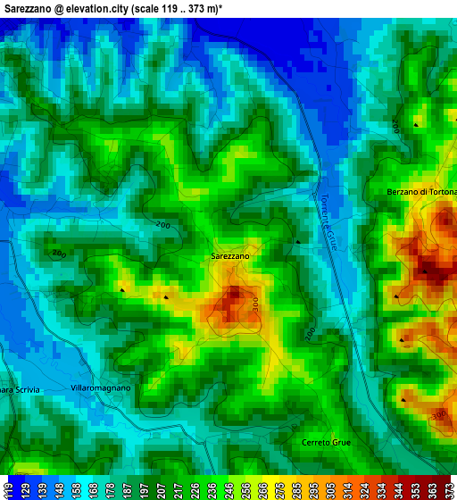
Below is the Elevation map of Sarezzano, which displays elevation range with different colors. Scale of the first map is from 119 to 373 m (390 to 1224 ft) with average elevation of 198.8 meters (=652 ft) [note 1]
These maps also provides idea of topography and contour of this city, they are displayed at different zoom levels. More info about maps, scale and edge coordinates you can find below images.
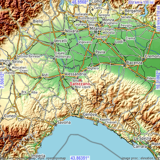
| \ | Map #1 | Topo.Map |
| Scale [m] | 119..373 m | × |
| Scale [ft] | 390..1224 ft | × |
| Average | 198.8 m = 652 ft | × |
| Width | 6.93 km = 4.3 mi | 221.6 km = 137.7 mi |
| Height | 6.93 km = 4.3 mi | 221.6 km = 137.7 mi |
| ↑Max Latitude | 44.899917° | 45.8568° |
| Latitude at center | 44.86878° | 44.86878° |
| ↓Min Latitude | 44.837626° | 43.86351° |
| ← Min Longitude | 8.868425° | 7.50612° |
| Longitude center | 8.91237° | 8.91237° |
| →Max Longitude | 8.956315° | 10.31862° |
Nearby cities:
Cities around Sarezzano sort by population:
• Tortona elevation 124 m
5 km,  310°
310°
• Viguzzolo 130 m
4.1 km,  7°
7°
• Villaromagnano 169 m
2.9 km,  222°
222°
• Carbonara Scrivia 179 m
4 km,  236°
236°
• Castellar Guidobono 150 m
4.9 km,  35°
35°
• Spineto Scrivia 262 m
4.6 km, 221°
• Paderna 267 m
5.5 km,  197°
197°
• Cerreto Grue 242 m
3.2 km,  154°
154°
• Monleale 297 m
5.2 km,  70°
70°
• Volpeglino 229 m
4.6 km,  54°
54°
• Berzano di Tortona 285 m
3.2 km, 73°
• Montegioco 327 m
5 km,  126°
126°
Multilingual:
 En español:
Sarezzano elevación 240 m.
 En France:
Sarezzano élévation 240 m.
 Auf Deutsch:
Sarezzano höhe über dem Meeresspiegel ist 240 m.

Sources and notes:
- [note 1] Map square and city borders are not equal. Map elevation data is calculated only from area inside that square.
- [src 1] Elevation data from geonames database provided with same terms of usage.
- [src 2] The elevation map of Sarezzano is generated using elevation data from NASA's 3 arcsec (90m) resolution SRTM data.
- [src 3] Base (background) map © OpenStreetMap contributors tiles are generated by Geofabrik and OpenTopoMap.
Copyright & License:
This Sarezzano Elevation Map is licensed under CC BY-SA. You may reuse any part from this page, if you give a proper credit by linking to this URL:
 More info on terms of use page.