Sarnano elevation
Sarnano (The Marches, Provincia di Macerata), Italy elevation is 514 meters and Sarnano elevation in feet is 1686 ft above sea level [src 1]. Sarnano is a seat of a third-order administrative division (feature code) with elevation that is 192 meters (630 ft) bigger than average city elevation in Italy.
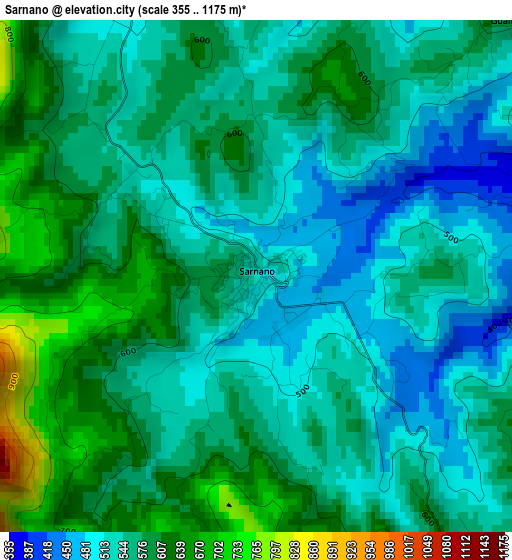
Below is the Elevation map of Sarnano, which displays elevation range with different colors. Scale of the first map is from 355 to 1175 m (1165 to 3855 ft) with average elevation of 563.9 meters (=1850 ft) [note 1]
These maps also provides idea of topography and contour of this city, they are displayed at different zoom levels. More info about maps, scale and edge coordinates you can find below images.
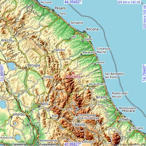
| \ | Map #1 | Topo.Map |
| Scale [m] | 355..1175 m | × |
| Scale [ft] | 1165..3855 ft | × |
| Average | 563.9 m = 1850 ft | × |
| Width | 7.14 km = 4.4 mi | 228.6 km = 142 mi |
| Height | 7.14 km = 4.4 mi | 228.6 km = 142 mi |
| ↑Max Latitude | 43.066863° | 44.05402° |
| Latitude at center | 43.03475° | 43.03475° |
| ↓Min Latitude | 43.00262° | 41.99827° |
| ← Min Longitude | 13.254235° | 11.89193° |
| Longitude center | 13.29818° | 13.29818° |
| →Max Longitude | 13.342125° | 14.70443° |
Nearby cities:
Cities around Sarnano sort by population:
• Amandola elevation 478 m
7.8 km,  143°
143°
• San Ginesio 664 m
8.3 km,  13°
13°
• Penna San Giovanni 599 m
10.6 km,  77°
77°
• Sant'Angelo in Pontano 455 m
10.7 km,  48°
48°
• Montefortino 601 m
10.8 km,  159°
159°
• Gualdo 604 m
5 km, 46°
• Monte San Martino 546 m
11.6 km,  91°
91°
• Camporotondo di Fiastrone 335 m
11.1 km,  346°
346°
• Trebbio 736 m
11.7 km,  271°
271°
• Bolognola 1038 m
7.4 km,  231°
231°
• Cessapalombo 444 m
8.8 km,  338°
338°
• Pie' del Colle 740 m
10 km, 266°
Multilingual:
 En español:
Sarnano elevación 514 m.
 En France:
Sarnano élévation 514 m.


Sources and notes:
- [note 1] Map square and city borders are not equal. Map elevation data is calculated only from area inside that square.
- [src 1] Elevation data from geonames database provided with same terms of usage.
- [src 2] The elevation map of Sarnano is generated using elevation data from NASA's 3 arcsec (90m) resolution SRTM data.
- [src 3] Base (background) map © OpenStreetMap contributors tiles are generated by Geofabrik and OpenTopoMap.
Copyright & License:
This Sarnano Elevation Map is licensed under CC BY-SA. You may reuse any part from this page, if you give a proper credit by linking to this URL:
 More info on terms of use page.