Semiana elevation
Semiana (Lombardy, Provincia di Pavia), Italy elevation is 98 meters and Semiana elevation in feet is 322 ft above sea level [src 1]. Semiana is a seat of a third-order administrative division (feature code) with elevation that is 224 meters (735 ft) smaller than average city elevation in Italy.
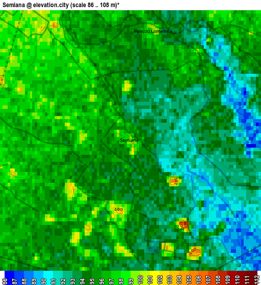
Below is the Elevation map of Semiana, which displays elevation range with different colors. Scale of the first map is from 86 to 108 m (282 to 354 ft) with average elevation of 94.5 meters (=310 ft) [note 1]
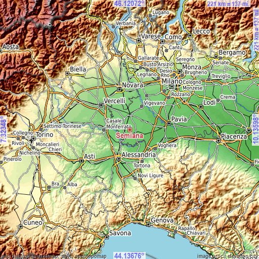
These maps also provides idea of topography and contour of this city, they are displayed at different zoom levels. More info about maps, scale and edge coordinates you can find below images.
| \ | Map #1 | Topo.Map |
| Scale [m] | 86..108 m | × |
| Scale [ft] | 282..354 ft | × |
| Average | 94.5 m = 310 ft | × |
| Width | 6.89 km = 4.3 mi | 220.6 km = 137.1 mi |
| Height | 6.89 km = 4.3 mi | 220.6 km = 137.1 mi |
| ↑Max Latitude | 45.168361° | 46.12072° |
| Latitude at center | 45.13737° | 45.13737° |
| ↓Min Latitude | 45.106362° | 44.13676° |
| ← Min Longitude | 8.685785° | 7.32348° |
| Longitude center | 8.72973° | 8.72973° |
| →Max Longitude | 8.773675° | 10.13598° |
Nearby cities:
Cities around Semiana sort by population:
• Mede elevation 97 m
4.5 km,  173°
173°
• Valle Lomellina 103 m
5 km,  287°
287°
• Lomello 93 m
5.6 km,  110°
110°
• Sartirana Lomellina 99 m
5.6 km,  241°
241°
• San Giorgio di Lomellina 100 m
6.3 km,  48°
48°
• Ottobiano 96 m
8.2 km,  76°
76°
• Zeme 106 m
8.2 km,  323°
323°
• Breme 105 m
8.2 km,  262°
262°
• Cergnago 104 m
7.5 km,  25°
25°
• Galliavola 92 m
8.3 km,  122°
122°
• Villa Biscossi 96 m
6.9 km,  139°
139°
• Velezzo Lomellina 100 m
2.9 km,  11°
11°
Multilingual:
 En español:
Semiana elevación 98 m.
 En France:
Semiana élévation 98 m.


Sources and notes:
- [note 1] Map square and city borders are not equal. Map elevation data is calculated only from area inside that square.
- [src 1] Elevation data from geonames database provided with same terms of usage.
- [src 2] The elevation map of Semiana is generated using elevation data from NASA's 3 arcsec (90m) resolution SRTM data.
- [src 3] Base (background) map © OpenStreetMap contributors tiles are generated by Geofabrik and OpenTopoMap.
Copyright & License:
This Semiana Elevation Map is licensed under CC BY-SA. You may reuse any part from this page, if you give a proper credit by linking to this URL:
 More info on terms of use page.