Sennori elevation
Sennori (Sardinia, Provincia di Sassari), Italy elevation is 252 meters and Sennori elevation in feet is 827 ft above sea level [src 1]. Sennori is a seat of a third-order administrative division (feature code) with elevation that is 70 meters (230 ft) smaller than average city elevation in Italy.
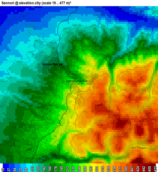
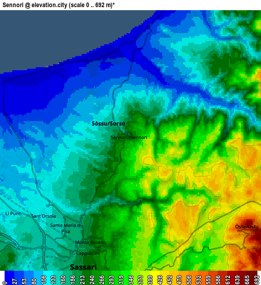
Below is the Elevation map of Sennori, which displays elevation range with different colors. Scale of the first map is from 19 to 477 m (62 to 1565 ft) with average elevation of 210.2 meters (=690 ft) [note 1]
These maps also provides idea of topography and contour of this city, they are displayed at different zoom levels. More info about maps, scale and edge coordinates you can find below images.
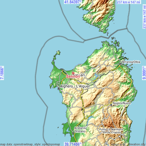
| \ | Map #1 | Map #2 | Topo.Map |
| Scale [m] | 19..477 m | 0..692 m | × |
| Scale [ft] | 62..1565 ft | 0..2270 ft | × |
| Average | 210.2 m = 690 ft | 210 m = 689 ft | × |
| Width | 7.4 km = 4.6 mi | 14.8 km = 9.2 mi | 236.8 km = 147.1 mi |
| Height | 7.4 km = 4.6 mi | 14.8 km = 9.2 mi | 236.8 km = 147.1 mi |
| ↑Max Latitude | 40.821064° | 40.854312° | 41.84397° |
| Latitude at center | 40.7878° | 40.7878° | 40.7878° |
| ↓Min Latitude | 40.754519° | 40.721222° | 39.71456° |
| ← Min Longitude | 8.548905° | 8.504959° | 7.1866° |
| Longitude center | 8.59285° | 8.59285° | 8.59285° |
| →Max Longitude | 8.636795° | 8.680741° | 9.9991° |
Nearby cities:
Cities around Sennori sort by population:
• Sassari elevation 190 m
7.6 km,  204°
204°
• Sorso 131 m
1.9 km,  311°
311°
• Li Punti-San Giovanni 89 m
9.2 km,  252°
252°
• Ossi 321 m
12.6 km,  180°
180°
• Nulvi 481 m
12.7 km,  91°
91°
• Osilo 616 m
8.2 km,  126°
126°
• Tissi 239 m
12.5 km,  192°
192°
• Ottava 70 m
9.9 km,  268°
268°
• Bancali 84 m
12.4 km,  241°
241°
• Muros 294 m
12.3 km,  170°
170°
• Cargeghe 322 m
13.3 km, 171°
• Tergu 277 m
13.5 km,  49°
49°
Multilingual:
 En español:
Sennori elevación 252 m.
 En France:
Sennori élévation 252 m.


Sources and notes:
- [note 1] Map square and city borders are not equal. Map elevation data is calculated only from area inside that square.
- [src 1] Elevation data from geonames database provided with same terms of usage.
- [src 2] The elevation map of Sennori is generated using elevation data from NASA's 3 arcsec (90m) resolution SRTM data.
- [src 3] Base (background) map © OpenStreetMap contributors tiles are generated by Geofabrik and OpenTopoMap.
Copyright & License:
This Sennori Elevation Map is licensed under CC BY-SA. You may reuse any part from this page, if you give a proper credit by linking to this URL:
 More info on terms of use page.