Serracapriola elevation
Serracapriola (Apulia, Provincia di Foggia), Italy elevation is 265 meters and Serracapriola elevation in feet is 869 ft above sea level [src 1]. Serracapriola is a seat of a third-order administrative division (feature code) with elevation that is 57 meters (187 ft) smaller than average city elevation in Italy.
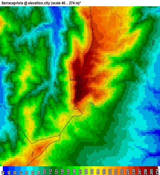
Below is the Elevation map of Serracapriola, which displays elevation range with different colors. Scale of the first map is from 40 to 274 m (131 to 899 ft) with average elevation of 135.5 meters (=445 ft) [note 1]
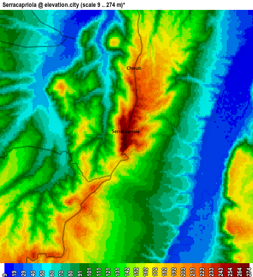
These maps also provides idea of topography and contour of this city, they are displayed at different zoom levels. More info about maps, scale and edge coordinates you can find below images.
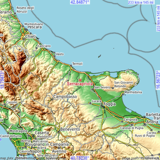
| \ | Map #1 | Map #2 | Topo.Map |
| Scale [m] | 40..274 m | 9..274 m | × |
| Scale [ft] | 131..899 ft | 30..899 ft | × |
| Average | 135.5 m = 445 ft | 105.5 m = 346 ft | × |
| Width | 7.28 km = 4.5 mi | 14.57 km = 9.1 mi | 233.1 km = 144.8 mi |
| Height | 7.28 km = 4.5 mi | 14.57 km = 9.1 mi | 233.1 km = 144.8 mi |
| ↑Max Latitude | 41.841867° | 41.874598° | 42.84871° |
| Latitude at center | 41.80912° | 41.80912° | 41.80912° |
| ↓Min Latitude | 41.776356° | 41.743575° | 40.75238° |
| ← Min Longitude | 15.117035° | 15.073089° | 13.75473° |
| Longitude center | 15.16098° | 15.16098° | 15.16098° |
| →Max Longitude | 15.204925° | 15.248871° | 16.56723° |
Nearby cities:
Cities around Serracapriola sort by population:
• Torremaggiore elevation 167 m
17.3 km,  140°
140°
• Lesina 7 m
16.9 km,  70°
70°
• San Paolo di Civitate 189 m
11.4 km,  133°
133°
• Santa Croce di Magliano 627 m
18 km,  233°
233°
• Campomarino 54 m
19.4 km,  327°
327°
• San Martino in Pensilis 224 m
14.1 km,  302°
302°
• Poggio Imperiale 73 m
17.1 km,  84°
84°
• Ururi 252 m
12 km,  273°
273°
• Portocannone 148 m
17.2 km,  312°
312°
• Chieuti 220 m
4 km,  6°
6°
• Rotello 362 m
14.5 km,  242°
242°
• Montelongo 577 m
19.2 km,  245°
245°
Multilingual:
 En español:
Serracapriola elevación 265 m.
 En France:
Serracapriola élévation 265 m.
 Auf Deutsch:
Serracapriola höhe über dem Meeresspiegel ist 265 m.

Sources and notes:
- [note 1] Map square and city borders are not equal. Map elevation data is calculated only from area inside that square.
- [src 1] Elevation data from geonames database provided with same terms of usage.
- [src 2] The elevation map of Serracapriola is generated using elevation data from NASA's 3 arcsec (90m) resolution SRTM data.
- [src 3] Base (background) map © OpenStreetMap contributors tiles are generated by Geofabrik and OpenTopoMap.
Copyright & License:
This Serracapriola Elevation Map is licensed under CC BY-SA. You may reuse any part from this page, if you give a proper credit by linking to this URL:
 More info on terms of use page.