Serrone elevation
Serrone (Latium, Provincia di Frosinone), Italy elevation is 689 meters and Serrone elevation in feet is 2260 ft above sea level [src 1]. Serrone is a seat of a third-order administrative division (feature code) with elevation that is 367 meters (1204 ft) bigger than average city elevation in Italy.
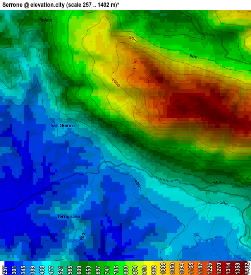
Below is the Elevation map of Serrone, which displays elevation range with different colors. Scale of the first map is from 257 to 1402 m (843 to 4600 ft) with average elevation of 626.3 meters (=2055 ft) [note 1]
These maps also provides idea of topography and contour of this city, they are displayed at different zoom levels. More info about maps, scale and edge coordinates you can find below images.
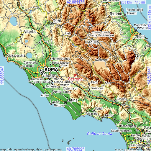
| \ | Map #1 | Topo.Map |
| Scale [m] | 257..1402 m | × |
| Scale [ft] | 843..4600 ft | × |
| Average | 626.3 m = 2055 ft | × |
| Width | 7.28 km = 4.5 mi | 233 km = 144.8 mi |
| Height | 7.28 km = 4.5 mi | 233 km = 144.8 mi |
| ↑Max Latitude | 41.87485° | 42.88117° |
| Latitude at center | 41.84212° | 41.84212° |
| ↓Min Latitude | 41.809373° | 40.78592° |
| ← Min Longitude | 13.051245° | 11.68894° |
| Longitude center | 13.09519° | 13.09519° |
| →Max Longitude | 13.139135° | 14.50144° |
Nearby cities:
Cities around Serrone sort by population:
• Subiaco elevation 391 m
9.4 km,  356°
356°
• Paliano 367 m
7.1 km,  192°
192°
• Olevano Romano 490 m
5.2 km,  290°
290°
• Piglio 621 m
3.4 km,  113°
113°
• Bellegra 748 m
7.1 km,  308°
308°
• Acuto 680 m
8.7 km,  130°
130°
• La Forma 411 m
0.9 km,  202°
202°
• Affile 690 m
4.7 km,  3°
3°
• Arcinazzo Romano 792 m
4.5 km,  20°
20°
• Rocca Santo Stefano 648 m
9.6 km,  322°
322°
• Roiate 687 m
4.2 km,  325°
325°
• Jenne 867 m
8.1 km,  49°
49°
Multilingual:
 En español:
Serrone elevación 689 m.
 En France:
Serrone élévation 689 m.


Sources and notes:
- [note 1] Map square and city borders are not equal. Map elevation data is calculated only from area inside that square.
- [src 1] Elevation data from geonames database provided with same terms of usage.
- [src 2] The elevation map of Serrone is generated using elevation data from NASA's 3 arcsec (90m) resolution SRTM data.
- [src 3] Base (background) map © OpenStreetMap contributors tiles are generated by Geofabrik and OpenTopoMap.
Copyright & License:
This Serrone Elevation Map is licensed under CC BY-SA. You may reuse any part from this page, if you give a proper credit by linking to this URL:
 More info on terms of use page.