Silandro elevation
Silandro (Trentino-Alto Adige, Bolzano), Italy elevation is 742 meters and Silandro elevation in feet is 2434 ft above sea level [src 1]. Silandro is a seat of a third-order administrative division (feature code) with elevation that is 420 meters (1378 ft) bigger than average city elevation in Italy.
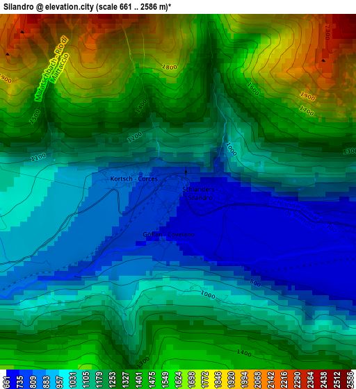
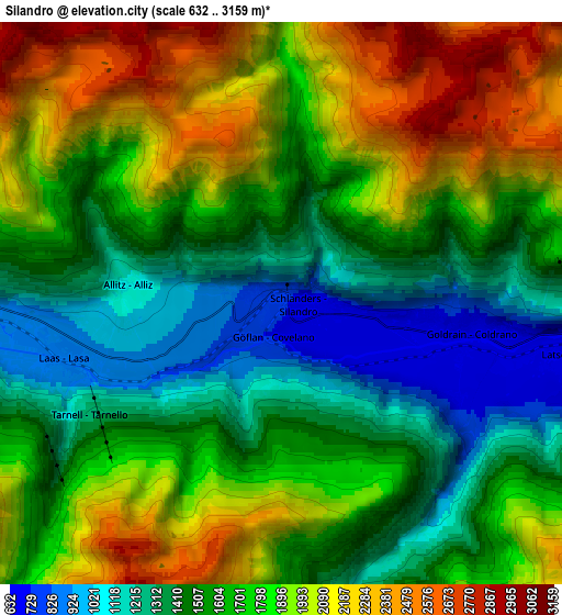
Below is the Elevation map of Silandro, which displays elevation range with different colors. Scale of the first map is from 661 to 2586 m (2169 to 8484 ft) with average elevation of 1233.5 meters (=4047 ft) [note 1]
These maps also provides idea of topography and contour of this city, they are displayed at different zoom levels. More info about maps, scale and edge coordinates you can find below images.
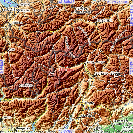
| \ | Map #1 | Map #2 | Topo.Map |
| Scale [m] | 661..2586 m | 632..3159 m | × |
| Scale [ft] | 2169..8484 ft | 2073..10364 ft | × |
| Average | 1233.5 m = 4047 ft | 1703.1 m = 5588 ft | × |
| Width | 6.71 km = 4.2 mi | 13.42 km = 8.3 mi | 214.8 km = 133.5 mi |
| Height | 6.71 km = 4.2 mi | 13.42 km = 8.3 mi | 214.7 km = 133.4 mi |
| ↑Max Latitude | 46.65848° | 46.688633° | 47.58541° |
| Latitude at center | 46.62831° | 46.62831° | 46.62831° |
| ↓Min Latitude | 46.598123° | 46.567919° | 45.65398° |
| ← Min Longitude | 10.724145° | 10.680199° | 9.36184° |
| Longitude center | 10.76809° | 10.76809° | 10.76809° |
| →Max Longitude | 10.812035° | 10.855981° | 12.17434° |
Nearby cities:
Cities around Silandro sort by population:
• Prato Allo Stelvio elevation 907 m
13.5 km,  265°
265°
• Laces 640 m
6.9 km,  100°
100°
• Castelbello-Ciardes - Kastelbell-Tschars 570 m
10.6 km,  89°
89°
• Lasa 868 m
5.5 km,  257°
257°
• Sluderno 920 m
14.7 km,  286°
286°
• Senales 1343 m
13.8 km,  51°
51°
• Castelbello 568 m
10.6 km, 89°
• Glorenza 911 m
16.8 km, 286°
• Stelvio 1291 m
17.3 km, 258°
• Certosa 1331 m
13.8 km, 52°
• Meiern 1311 m
7.1 km,  170°
170°
• Ganda 1268 m
8.3 km, 173°
Multilingual:
 En español:
Silandro elevación 742 m.
 En France:
Silandro élévation 742 m.
 Auf Deutsch:
Schlanders höhe über dem Meeresspiegel ist 742 m.

Sources and notes:
- [note 1] Map square and city borders are not equal. Map elevation data is calculated only from area inside that square.
- [src 1] Elevation data from geonames database provided with same terms of usage.
- [src 2] The elevation map of Silandro is generated using elevation data from NASA's 3 arcsec (90m) resolution SRTM data.
- [src 3] Base (background) map © OpenStreetMap contributors tiles are generated by Geofabrik and OpenTopoMap.
Copyright & License:
This Silandro Elevation Map is licensed under CC BY-SA. You may reuse any part from this page, if you give a proper credit by linking to this URL:
 More info on terms of use page.