Sillano elevation
Sillano (Tuscany, Provincia di Lucca), Italy elevation is 764 meters and Sillano elevation in feet is 2507 ft above sea level [src 1]. Sillano is a seat of a third-order administrative division (feature code) with elevation that is 442 meters (1450 ft) bigger than average city elevation in Italy.
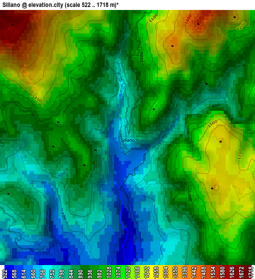
Below is the Elevation map of Sillano, which displays elevation range with different colors. Scale of the first map is from 522 to 1718 m (1713 to 5636 ft) with average elevation of 951.7 meters (=3122 ft) [note 1]
These maps also provides idea of topography and contour of this city, they are displayed at different zoom levels. More info about maps, scale and edge coordinates you can find below images.
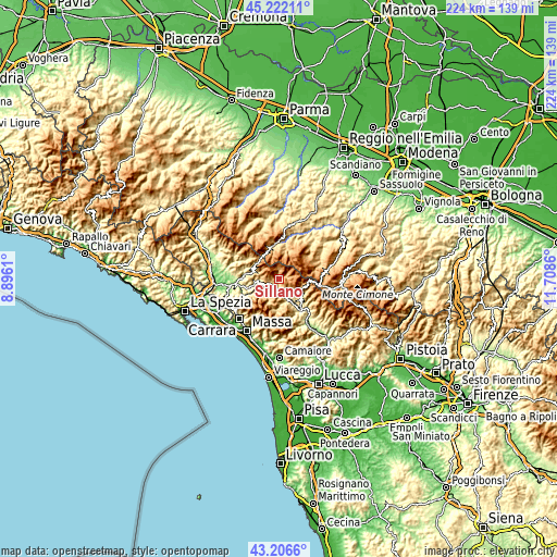
| \ | Map #1 | Topo.Map |
| Scale [m] | 522..1718 m | × |
| Scale [ft] | 1713..5636 ft | × |
| Average | 951.7 m = 3122 ft | × |
| Width | 7 km = 4.3 mi | 224.1 km = 139.2 mi |
| Height | 7 km = 4.3 mi | 224.1 km = 139.2 mi |
| ↑Max Latitude | 44.254464° | 45.22211° |
| Latitude at center | 44.22298° | 44.22298° |
| ↓Min Latitude | 44.191479° | 43.2066° |
| ← Min Longitude | 10.258405° | 8.8961° |
| Longitude center | 10.30235° | 10.30235° |
| →Max Longitude | 10.346295° | 11.7086° |
Nearby cities:
Cities around Sillano sort by population:
• San Romano in Garfagnana elevation 548 m
6.9 km,  149°
149°
• Piazza al Serchio-San Michele 513 m
4.3 km,  185°
185°
• Camporgiano 480 m
7.5 km,  160°
160°
• Castiglione di Garfagnana 570 m
11.7 km,  131°
131°
• Careggine 887 m
11.6 km,  170°
170°
• San Romano 547 m
6.8 km, 149°
• Fontana delle Monache 574 m
12.3 km, 188°
• Ligonchio 976 m
10.9 km,  17°
17°
• Casola in Lunigiana 333 m
10.3 km,  255°
255°
• Villa Collemandina 546 m
10.4 km, 133°
• Minucciano 668 m
9.5 km,  231°
231°
• Giuncugnano 872 m
4.6 km,  252°
252°
Multilingual:
 En español:
Sillano elevación 764 m.
 En France:
Sillano élévation 764 m.


Sources and notes:
- [note 1] Map square and city borders are not equal. Map elevation data is calculated only from area inside that square.
- [src 1] Elevation data from geonames database provided with same terms of usage.
- [src 2] The elevation map of Sillano is generated using elevation data from NASA's 3 arcsec (90m) resolution SRTM data.
- [src 3] Base (background) map © OpenStreetMap contributors tiles are generated by Geofabrik and OpenTopoMap.
Copyright & License:
This Sillano Elevation Map is licensed under CC BY-SA. You may reuse any part from this page, if you give a proper credit by linking to this URL:
 More info on terms of use page.