Soldano elevation
Soldano (Liguria, Provincia di Imperia), Italy elevation is 93 meters and Soldano elevation in feet is 305 ft above sea level [src 1]. Soldano is a seat of a third-order administrative division (feature code) with elevation that is 229 meters (751 ft) smaller than average city elevation in Italy.
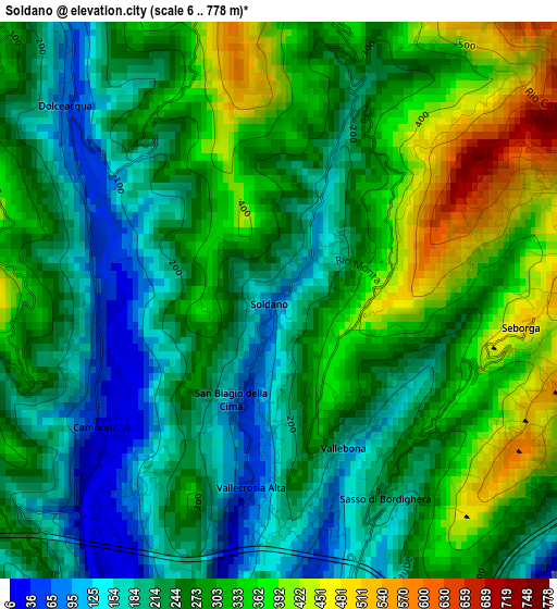
Below is the Elevation map of Soldano, which displays elevation range with different colors. Scale of the first map is from 6 to 778 m (20 to 2552 ft) with average elevation of 271.4 meters (=890 ft) [note 1]
These maps also provides idea of topography and contour of this city, they are displayed at different zoom levels. More info about maps, scale and edge coordinates you can find below images.
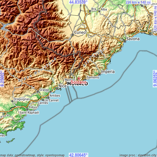
| \ | Map #1 | Topo.Map |
| Scale [m] | 6..778 m | × |
| Scale [ft] | 20..2552 ft | × |
| Average | 271.4 m = 890 ft | × |
| Width | 7.05 km = 4.4 mi | 225.6 km = 140.2 mi |
| Height | 7.05 km = 4.4 mi | 225.6 km = 140.2 mi |
| ↑Max Latitude | 43.861234° | 44.83539° |
| Latitude at center | 43.82954° | 43.82954° |
| ↓Min Latitude | 43.797829° | 42.80645° |
| ← Min Longitude | 7.612325° | 6.25002° |
| Longitude center | 7.65627° | 7.65627° |
| →Max Longitude | 7.700215° | 9.06252° |
Nearby cities:
Cities around Soldano sort by population:
• Ventimiglia elevation 10 m
5.9 km,  220°
220°
• Bordighera 11 m
5.5 km,  173°
173°
• Vallecrosia 12 m
5 km,  196°
196°
• Camporosso 25 m
2.9 km,  230°
230°
• Ospedaletti 34 m
5.8 km,  121°
121°
• Dolceacqua 61 m
3.4 km,  310°
310°
• San Biagio della Cima 58 m
1.4 km, 196°
• Vallebona 189 m
2.1 km,  159°
159°
• Perinaldo 535 m
4.3 km,  16°
16°
• Isolabona 104 m
5.8 km,  347°
347°
• Apricale 254 m
5.7 km,  2°
2°
• Seborga 507 m
3.2 km,  94°
94°
Multilingual:
 En español:
Soldano elevación 93 m.
 En France:
Soldano élévation 93 m.


Sources and notes:
- [note 1] Map square and city borders are not equal. Map elevation data is calculated only from area inside that square.
- [src 1] Elevation data from geonames database provided with same terms of usage.
- [src 2] The elevation map of Soldano is generated using elevation data from NASA's 3 arcsec (90m) resolution SRTM data.
- [src 3] Base (background) map © OpenStreetMap contributors tiles are generated by Geofabrik and OpenTopoMap.
Copyright & License:
This Soldano Elevation Map is licensed under CC BY-SA. You may reuse any part from this page, if you give a proper credit by linking to this URL:
 More info on terms of use page.