Sovere elevation
Sovere (Lombardy, Provincia di Bergamo), Italy elevation is 351 meters and Sovere elevation in feet is 1152 ft above sea level [src 1]. Sovere is a seat of a third-order administrative division (feature code) with elevation that is 29 meters (95 ft) bigger than average city elevation in Italy.
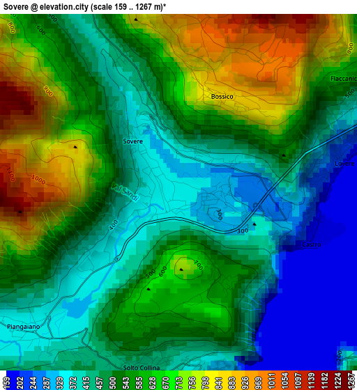
Below is the Elevation map of Sovere, which displays elevation range with different colors. Scale of the first map is from 159 to 1267 m (522 to 4157 ft) with average elevation of 541.1 meters (=1775 ft) [note 1]
These maps also provides idea of topography and contour of this city, they are displayed at different zoom levels. More info about maps, scale and edge coordinates you can find below images.
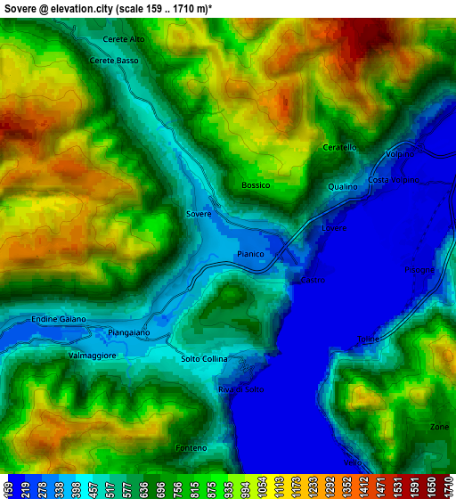
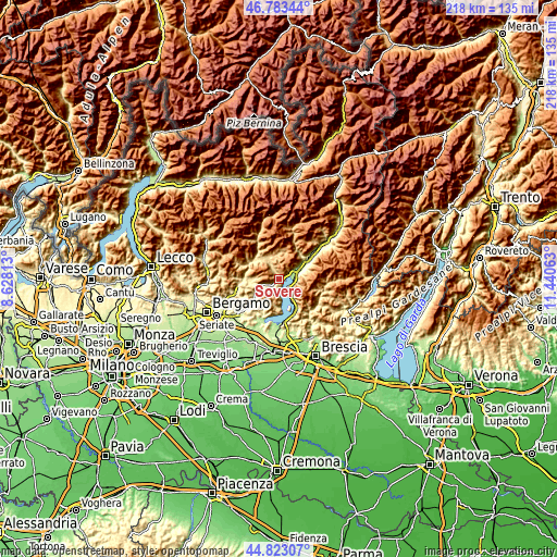
| \ | Map #1 | Map #2 | Topo.Map |
| Scale [m] | 159..1267 m | 159..1710 m | × |
| Scale [ft] | 522..4157 ft | 522..5610 ft | × |
| Average | 541.1 m = 1775 ft | 702.3 m = 2304 ft | × |
| Width | 6.81 km = 4.2 mi | 13.62 km = 8.5 mi | 218 km = 135.5 mi |
| Height | 6.81 km = 4.2 mi | 13.62 km = 8.5 mi | 218 km = 135.5 mi |
| ↑Max Latitude | 45.842502° | 45.873108° | 46.78344° |
| Latitude at center | 45.81188° | 45.81188° | 45.81188° |
| ↓Min Latitude | 45.781241° | 45.750585° | 44.82307° |
| ← Min Longitude | 9.990435° | 9.946489° | 8.62813° |
| Longitude center | 10.03438° | 10.03438° | 10.03438° |
| →Max Longitude | 10.078325° | 10.122271° | 11.44063° |
Nearby cities:
Cities around Sovere sort by population:
• Costa Volpino elevation 194 m
5.4 km,  71°
71°
• Lovere 215 m
2.8 km,  85°
85°
• Pisogne 190 m
5.9 km, 94°
• Piangaiano 354 m
4 km,  230°
230°
• Pianico 319 m
0.7 km,  108°
108°
• Endine 336 m
5.2 km,  241°
241°
• Castro 199 m
2.6 km, 110°
• Solto Collina 448 m
3.3 km,  190°
190°
• Bossico 855 m
2 km,  24°
24°
• Riva di Solto 195 m
4.2 km,  174°
174°
• Fonteno 655 m
6.1 km, 191°
• Cerete Alto 600 m
6.9 km,  333°
333°
Multilingual:
 En español:
Sovere elevación 351 m.
 En France:
Sovere élévation 351 m.


Sources and notes:
- [note 1] Map square and city borders are not equal. Map elevation data is calculated only from area inside that square.
- [src 1] Elevation data from geonames database provided with same terms of usage.
- [src 2] The elevation map of Sovere is generated using elevation data from NASA's 3 arcsec (90m) resolution SRTM data.
- [src 3] Base (background) map © OpenStreetMap contributors tiles are generated by Geofabrik and OpenTopoMap.
Copyright & License:
This Sovere Elevation Map is licensed under CC BY-SA. You may reuse any part from this page, if you give a proper credit by linking to this URL:
 More info on terms of use page.