Stellanello elevation
Stellanello (Liguria, Provincia di Savona), Italy elevation is 135 meters and Stellanello elevation in feet is 443 ft above sea level [src 1]. Stellanello is a seat of a third-order administrative division (feature code) with elevation that is 187 meters (614 ft) smaller than average city elevation in Italy.
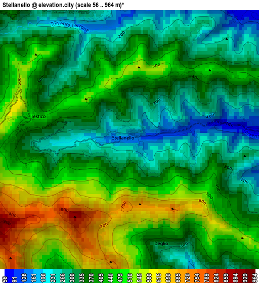
Below is the Elevation map of Stellanello, which displays elevation range with different colors. Scale of the first map is from 56 to 964 m (184 to 3163 ft) with average elevation of 391.8 meters (=1285 ft) [note 1]
These maps also provides idea of topography and contour of this city, they are displayed at different zoom levels. More info about maps, scale and edge coordinates you can find below images.
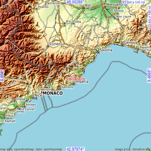
| \ | Map #1 | Topo.Map |
| Scale [m] | 56..964 m | × |
| Scale [ft] | 184..3163 ft | × |
| Average | 391.8 m = 1285 ft | × |
| Width | 7.03 km = 4.4 mi | 225 km = 139.8 mi |
| Height | 7.03 km = 4.4 mi | 224.9 km = 139.7 mi |
| ↑Max Latitude | 44.031533° | 45.00288° |
| Latitude at center | 43.99993° | 43.99993° |
| ↓Min Latitude | 43.96831° | 42.97974° |
| ← Min Longitude | 8.016305° | 6.654° |
| Longitude center | 8.06025° | 8.06025° |
| →Max Longitude | 8.104195° | 9.4665° |
Nearby cities:
Cities around Stellanello sort by population:
• Villafranca elevation 55 m
5.1 km,  44°
44°
• Ortovero 62 m
6.8 km,  27°
27°
• Garlenda 64 m
4.7 km, 37°
• Rossi 137 m
0.1 km,  289°
289°
• Chiusavecchia 145 m
7.1 km,  239°
239°
• Casanova Lerrone 303 m
3.7 km,  343°
343°
• Diano Arentino 311 m
5.8 km,  194°
194°
• Borgo di Ranzo 122 m
7.6 km,  331°
331°
• Chiusanico 375 m
6.2 km, 241°
• Cesio 527 m
6.9 km,  277°
277°
• Villa Faraldi 332 m
4.2 km,  146°
146°
• Testico 495 m
2.8 km, 282°
Multilingual:
 En español:
Stellanello elevación 135 m.
 En France:
Stellanello élévation 135 m.
 Auf Deutsch:
Stellanello höhe über dem Meeresspiegel ist 135 m.

Sources and notes:
- [note 1] Map square and city borders are not equal. Map elevation data is calculated only from area inside that square.
- [src 1] Elevation data from geonames database provided with same terms of usage.
- [src 2] The elevation map of Stellanello is generated using elevation data from NASA's 3 arcsec (90m) resolution SRTM data.
- [src 3] Base (background) map © OpenStreetMap contributors tiles are generated by Geofabrik and OpenTopoMap.
Copyright & License:
This Stellanello Elevation Map is licensed under CC BY-SA. You may reuse any part from this page, if you give a proper credit by linking to this URL:
 More info on terms of use page.