Strettoia elevation
Strettoia (Tuscany, Provincia di Lucca), Italy elevation is 27 meters and Strettoia elevation in feet is 89 ft above sea level [src 1]. Strettoia is a populated place (feature code) with elevation that is 295 meters (968 ft) smaller than average city elevation in Italy.
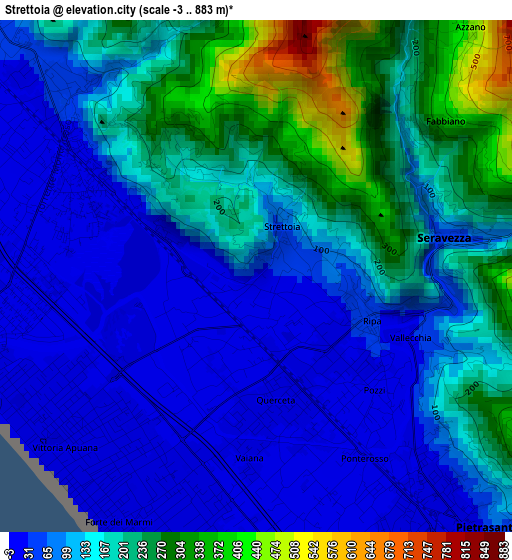
Below is the Elevation map of Strettoia, which displays elevation range with different colors. Scale of the first map is from -3 to 883 m (-10 to 2897 ft) with average elevation of 134.2 meters (=440 ft) [note 1]
These maps also provides idea of topography and contour of this city, they are displayed at different zoom levels. More info about maps, scale and edge coordinates you can find below images.
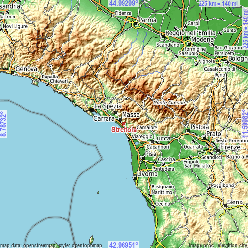
| \ | Map #1 | Topo.Map |
| Scale [m] | -3..883 m | × |
| Scale [ft] | -10..2897 ft | × |
| Average | 134.2 m = 440 ft | × |
| Width | 7.03 km = 4.4 mi | 225 km = 139.8 mi |
| Height | 7.03 km = 4.4 mi | 225 km = 139.8 mi |
| ↑Max Latitude | 44.021479° | 44.99299° |
| Latitude at center | 43.98987° | 43.98987° |
| ↓Min Latitude | 43.958245° | 42.96951° |
| ← Min Longitude | 10.149625° | 8.78732° |
| Longitude center | 10.19357° | 10.19357° |
| →Max Longitude | 10.237515° | 11.59982° |
Nearby cities:
Cities around Strettoia sort by population:
• Massa elevation 56 m
6.7 km,  319°
319°
• Camaiore 36 m
9.8 km,  122°
122°
• Marina di Massa 3 m
7.1 km,  282°
282°
• Pietrasanta 12 m
4.3 km,  140°
140°
• Montignoso 328 m
4.2 km,  336°
336°
• Ripa-Pozzi-Querceta-Ponterosso 22 m
1.5 km,  148°
148°
• Capanne-Prato-Cinquale 6 m
3.1 km,  285°
285°
• Forte dei Marmi 3 m
3.3 km,  207°
207°
• Piano di Mommio 5 m
11 km, 144°
• San Vito-Cerreto 301 m
4.1 km, 335°
• Seravezza 58 m
2.7 km,  78°
78°
• Pontestazzemese 167 m
8.1 km, 84°
Multilingual:
 En español:
Strettoia elevación 27 m.
 En France:
Strettoia élévation 27 m.
 Auf Deutsch:
Strettoia höhe über dem Meeresspiegel ist 27 m.

Sources and notes:
- [note 1] Map square and city borders are not equal. Map elevation data is calculated only from area inside that square.
- [src 1] Elevation data from geonames database provided with same terms of usage.
- [src 2] The elevation map of Strettoia is generated using elevation data from NASA's 3 arcsec (90m) resolution SRTM data.
- [src 3] Base (background) map © OpenStreetMap contributors tiles are generated by Geofabrik and OpenTopoMap.
Copyright & License:
This Strettoia Elevation Map is licensed under CC BY-SA. You may reuse any part from this page, if you give a proper credit by linking to this URL:
 More info on terms of use page.