Susa elevation
Susa (Piedmont, Torino), Italy elevation is 487 meters and Susa elevation in feet is 1598 ft above sea level [src 1]. Susa is a seat of a third-order administrative division (feature code) with elevation that is 165 meters (541 ft) bigger than average city elevation in Italy.
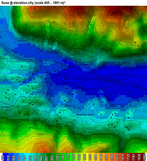
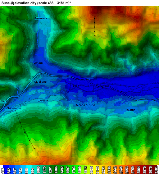
Below is the Elevation map of Susa, which displays elevation range with different colors. Scale of the first map is from 455 to 1891 m (1493 to 6204 ft) with average elevation of 888.6 meters (=2915 ft) [note 1]
These maps also provides idea of topography and contour of this city, they are displayed at different zoom levels. More info about maps, scale and edge coordinates you can find below images.
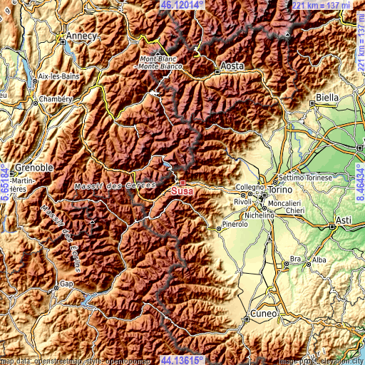
| \ | Map #1 | Map #2 | Topo.Map |
| Scale [m] | 455..1891 m | 436..3181 m | × |
| Scale [ft] | 1493..6204 ft | 1430..10436 ft | × |
| Average | 888.6 m = 2915 ft | 1361.5 m = 4467 ft | × |
| Width | 6.89 km = 4.3 mi | 13.79 km = 8.6 mi | 220.6 km = 137.1 mi |
| Height | 6.89 km = 4.3 mi | 13.79 km = 8.6 mi | 220.6 km = 137.1 mi |
| ↑Max Latitude | 45.167761° | 45.198736° | 46.12014° |
| Latitude at center | 45.13677° | 45.13677° | 45.13677° |
| ↓Min Latitude | 45.105762° | 45.074737° | 44.13615° |
| ← Min Longitude | 7.014145° | 6.970199° | 5.65184° |
| Longitude center | 7.05809° | 7.05809° | 7.05809° |
| →Max Longitude | 7.102035° | 7.145981° | 8.46434° |
Nearby cities:
Cities around Susa sort by population:
• Bussoleno elevation 444 m
6.8 km,  87°
87°
• Venaus 605 m
4.3 km,  301°
301°
• San Giorio 427 m
9.4 km,  96°
96°
• Chiomonte 751 m
6.1 km,  251°
251°
• Mompantero 528 m
1.7 km,  315°
315°
• Meana di Susa 672 m
1.7 km,  162°
162°
• Mattie 732 m
4.9 km,  114°
114°
• Gravere 777 m
3.4 km, 248°
• Giaglione 714 m
3.4 km,  274°
274°
• Novalesa 830 m
6.9 km,  330°
330°
• San Giuseppe 526 m
1.7 km,  313°
313°
• Chianocco 552 m
8.9 km,  81°
81°
Multilingual:
 En español:
Susa elevación 487 m.
 En France:
Suse élévation 487 m.


Sources and notes:
- [note 1] Map square and city borders are not equal. Map elevation data is calculated only from area inside that square.
- [src 1] Elevation data from geonames database provided with same terms of usage.
- [src 2] The elevation map of Susa is generated using elevation data from NASA's 3 arcsec (90m) resolution SRTM data.
- [src 3] Base (background) map © OpenStreetMap contributors tiles are generated by Geofabrik and OpenTopoMap.
Copyright & License:
This Susa Elevation Map is licensed under CC BY-SA. You may reuse any part from this page, if you give a proper credit by linking to this URL:
 More info on terms of use page.