Taneto elevation
Taneto (Emilia-Romagna, Provincia di Reggio Emilia), Italy elevation is 50 meters and Taneto elevation in feet is 164 ft above sea level [src 1]. Taneto is a populated place (feature code) with elevation that is 272 meters (892 ft) smaller than average city elevation in Italy.
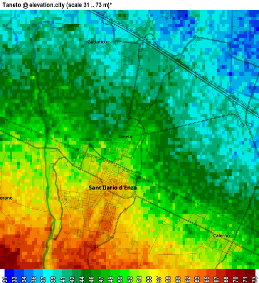
Below is the Elevation map of Taneto, which displays elevation range with different colors. Scale of the first map is from 31 to 73 m (102 to 240 ft) with average elevation of 47.5 meters (=156 ft) [note 1]
These maps also provides idea of topography and contour of this city, they are displayed at different zoom levels. More info about maps, scale and edge coordinates you can find below images.
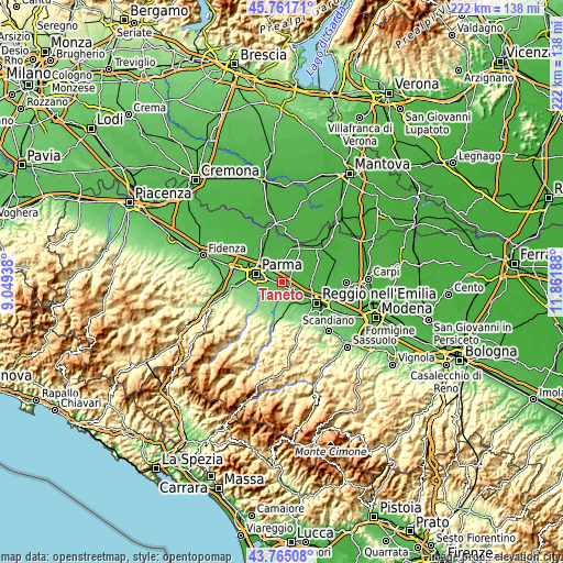
| \ | Map #1 | Topo.Map |
| Scale [m] | 31..73 m | × |
| Scale [ft] | 102..240 ft | × |
| Average | 47.5 m = 156 ft | × |
| Width | 6.94 km = 4.3 mi | 222 km = 137.9 mi |
| Height | 6.94 km = 4.3 mi | 222 km = 137.9 mi |
| ↑Max Latitude | 44.803209° | 45.76171° |
| Latitude at center | 44.77202° | 44.77202° |
| ↓Min Latitude | 44.740814° | 43.76508° |
| ← Min Longitude | 10.411685° | 9.04938° |
| Longitude center | 10.45563° | 10.45563° |
| →Max Longitude | 10.499575° | 11.86188° |
Nearby cities:
Cities around Taneto sort by population:
• Montecchio Emilia elevation 102 m
8.1 km,  181°
181°
• Sant'Ilario d'Enza 60 m
1.6 km,  204°
204°
• Sorbolo 35 m
8.3 km,  353°
353°
• Monticelli Terme 95 m
6.8 km,  225°
225°
• Praticello 36 m
3.9 km,  20°
20°
• Campegine 36 m
5.8 km,  80°
80°
• Calerno 53 m
3.5 km,  137°
137°
• Cadè-Gaida 50 m
6 km,  128°
128°
• Caprara 37 m
4.4 km,  85°
85°
• Basilicagoiano 115 m
8.4 km,  208°
208°
• San Prospero 52 m
4.3 km,  276°
276°
• Praticello di Gattatico 39 m
3.9 km, 22°
Multilingual:
 En español:
Taneto elevación 50 m.
 En France:
Taneto élévation 50 m.


Sources and notes:
- [note 1] Map square and city borders are not equal. Map elevation data is calculated only from area inside that square.
- [src 1] Elevation data from geonames database provided with same terms of usage.
- [src 2] The elevation map of Taneto is generated using elevation data from NASA's 3 arcsec (90m) resolution SRTM data.
- [src 3] Base (background) map © OpenStreetMap contributors tiles are generated by Geofabrik and OpenTopoMap.
Copyright & License:
This Taneto Elevation Map is licensed under CC BY-SA. You may reuse any part from this page, if you give a proper credit by linking to this URL:
 More info on terms of use page.