Tavenna elevation
Tavenna (Molise, Provincia di Campobasso), Italy elevation is 547 meters and Tavenna elevation in feet is 1795 ft above sea level [src 1]. Tavenna is a seat of a third-order administrative division (feature code) with elevation that is 225 meters (738 ft) bigger than average city elevation in Italy.
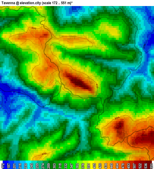
Below is the Elevation map of Tavenna, which displays elevation range with different colors. Scale of the first map is from 172 to 551 m (564 to 1808 ft) with average elevation of 328.5 meters (=1078 ft) [note 1]
These maps also provides idea of topography and contour of this city, they are displayed at different zoom levels. More info about maps, scale and edge coordinates you can find below images.
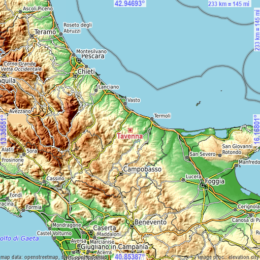
| \ | Map #1 | Topo.Map |
| Scale [m] | 172..551 m | × |
| Scale [ft] | 564..1808 ft | × |
| Average | 328.5 m = 1078 ft | × |
| Width | 7.27 km = 4.5 mi | 232.7 km = 144.6 mi |
| Height | 7.27 km = 4.5 mi | 232.7 km = 144.6 mi |
| ↑Max Latitude | 41.941676° | 42.94693° |
| Latitude at center | 41.90898° | 41.90898° |
| ↓Min Latitude | 41.876267° | 40.85387° |
| ← Min Longitude | 14.717815° | 13.35551° |
| Longitude center | 14.76176° | 14.76176° |
| →Max Longitude | 14.805705° | 16.16801° |
Nearby cities:
Cities around Tavenna sort by population:
• Montenero di Bisaccia elevation 176 m
6.4 km,  14°
14°
• Castelmauro 677 m
9.9 km,  205°
205°
• Palata 482 m
3.2 km,  137°
137°
• Montefalcone nel Sannio 607 m
11.3 km,  245°
245°
• Montecilfone 392 m
6.3 km,  97°
97°
• Mafalda 444 m
5.4 km,  315°
315°
• Fresagrandinaria 387 m
11.3 km,  313°
313°
• Acquaviva Collecroce 442 m
4.9 km,  194°
194°
• San Felice del Molise 516 m
5.5 km, 247°
• Tufillo 556 m
11.3 km,  274°
274°
• Montemitro 483 m
9.8 km,  256°
256°
• Dogliola 446 m
11.1 km,  289°
289°
Multilingual:
 En español:
Tavenna elevación 547 m.
 En France:
Tavenna élévation 547 m.


Sources and notes:
- [note 1] Map square and city borders are not equal. Map elevation data is calculated only from area inside that square.
- [src 1] Elevation data from geonames database provided with same terms of usage.
- [src 2] The elevation map of Tavenna is generated using elevation data from NASA's 3 arcsec (90m) resolution SRTM data.
- [src 3] Base (background) map © OpenStreetMap contributors tiles are generated by Geofabrik and OpenTopoMap.
Copyright & License:
This Tavenna Elevation Map is licensed under CC BY-SA. You may reuse any part from this page, if you give a proper credit by linking to this URL:
 More info on terms of use page.