Toano elevation
Toano (Emilia-Romagna, Provincia di Reggio Emilia), Italy elevation is 855 meters and Toano elevation in feet is 2805 ft above sea level [src 1]. Toano is a seat of a third-order administrative division (feature code) with elevation that is 533 meters (1749 ft) bigger than average city elevation in Italy.
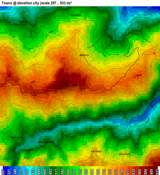
Below is the Elevation map of Toano, which displays elevation range with different colors. Scale of the first map is from 297 to 933 m (974 to 3061 ft) with average elevation of 624.4 meters (=2049 ft) [note 1]
These maps also provides idea of topography and contour of this city, they are displayed at different zoom levels. More info about maps, scale and edge coordinates you can find below images.
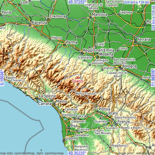
| \ | Map #1 | Topo.Map |
| Scale [m] | 297..933 m | × |
| Scale [ft] | 974..3061 ft | × |
| Average | 624.4 m = 2049 ft | × |
| Width | 6.99 km = 4.3 mi | 223.5 km = 138.9 mi |
| Height | 6.99 km = 4.3 mi | 223.5 km = 138.9 mi |
| ↑Max Latitude | 44.407412° | 45.37252° |
| Latitude at center | 44.37601° | 44.37601° |
| ↓Min Latitude | 44.344591° | 43.36225° |
| ← Min Longitude | 10.519165° | 9.15686° |
| Longitude center | 10.56311° | 10.56311° |
| →Max Longitude | 10.607055° | 11.96936° |
Nearby cities:
Cities around Toano sort by population:
• Castelnovo ne'Monti elevation 711 m
14.3 km,  297°
297°
• Prignano sulla Secchia 574 m
12.4 km,  55°
55°
• Felina 670 m
12 km,  317°
317°
• Carpineti 546 m
9.6 km,  337°
337°
• Villa Minozzo 670 m
7.9 km,  260°
260°
• Lama 837 m
15.4 km,  119°
119°
• Baiso 534 m
13.7 km,  12°
12°
• Palagano 705 m
9 km,  132°
132°
• Prignano 556 m
12.3 km, 55°
• Frassinoro 1111 m
9.1 km,  175°
175°
• Polinago 792 m
13.4 km,  104°
104°
• Montefiorino 736 m
5.4 km, 117°
Multilingual:
 En español:
Toano elevación 855 m.
 En France:
Toano élévation 855 m.


Sources and notes:
- [note 1] Map square and city borders are not equal. Map elevation data is calculated only from area inside that square.
- [src 1] Elevation data from geonames database provided with same terms of usage.
- [src 2] The elevation map of Toano is generated using elevation data from NASA's 3 arcsec (90m) resolution SRTM data.
- [src 3] Base (background) map © OpenStreetMap contributors tiles are generated by Geofabrik and OpenTopoMap.
Copyright & License:
This Toano Elevation Map is licensed under CC BY-SA. You may reuse any part from this page, if you give a proper credit by linking to this URL:
 More info on terms of use page.