Turin elevation
Turin (Piedmont, Torino), Italy elevation is 245 meters and Turin elevation in feet is 804 ft above sea level [src 1]. Turin is a seat of a first-order administrative division (feature code) with elevation that is 77 meters (253 ft) smaller than average city elevation in Italy.
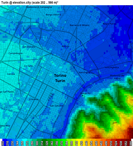
Below is the Elevation map of Turin, which displays elevation range with different colors. Scale of the first map is from 202 to 566 m (663 to 1857 ft) with average elevation of 261 meters (=856 ft) [note 1]
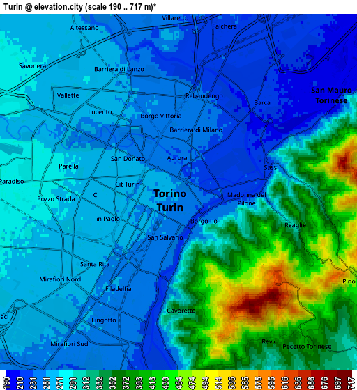
These maps also provides idea of topography and contour of this city, they are displayed at different zoom levels. More info about maps, scale and edge coordinates you can find below images.
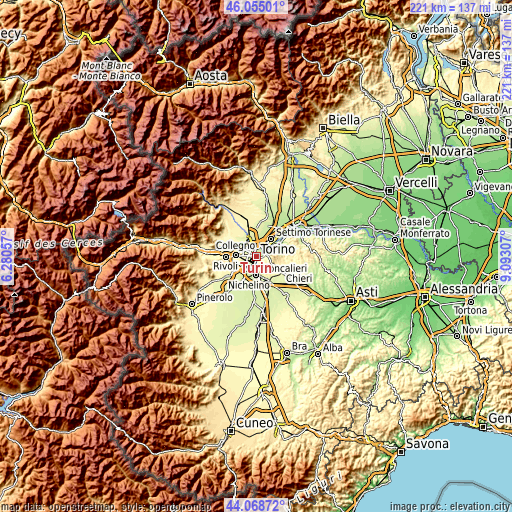
| \ | Map #1 | Map #2 | Topo.Map |
| Scale [m] | 202..566 m | 190..717 m | × |
| Scale [ft] | 663..1857 ft | 623..2352 ft | × |
| Average | 261 m = 856 ft | 291.6 m = 957 ft | × |
| Width | 6.9 km = 4.3 mi | 13.8 km = 8.6 mi | 220.9 km = 137.3 mi |
| Height | 6.9 km = 4.3 mi | 13.8 km = 8.6 mi | 220.8 km = 137.2 mi |
| ↑Max Latitude | 45.101517° | 45.132528° | 46.05501° |
| Latitude at center | 45.07049° | 45.07049° | 45.07049° |
| ↓Min Latitude | 45.039446° | 45.008385° | 44.06872° |
| ← Min Longitude | 7.642875° | 7.598929° | 6.28057° |
| Longitude center | 7.68682° | 7.68682° | 7.68682° |
| →Max Longitude | 7.730765° | 7.774711° | 9.09307° |
Nearby cities:
Cities around Turin sort by population:
• Moncalieri elevation 236 m
7.9 km,  182°
182°
• Nichelino 227 m
8.2 km,  198°
198°
• Venaria Reale 263 m
7.5 km,  324°
324°
• Grugliasco 297 m
8.4 km,  265°
265°
• San Mauro Torinese 252 m
7.4 km,  60°
60°
• Pino Torinese 418 m
7.9 km,  115°
115°
• Fornaci 263 m
8.4 km,  235°
235°
• Gerbido 265 m
6.4 km, 243°
• Pecetto 392 m
7.8 km,  139°
139°
• Revigliasco 332 m
7.1 km,  149°
149°
• Savonera 274 m
7.4 km,  310°
310°
• Lesna 269 m
5.5 km,  250°
250°
Multilingual:
 En español:
Turín elevación 245 m.
 En France:
Turin élévation 245 m.


Sources and notes:
- [note 1] Map square and city borders are not equal. Map elevation data is calculated only from area inside that square.
- [src 1] Elevation data from geonames database provided with same terms of usage.
- [src 2] The elevation map of Turin is generated using elevation data from NASA's 3 arcsec (90m) resolution SRTM data.
- [src 3] Base (background) map © OpenStreetMap contributors tiles are generated by Geofabrik and OpenTopoMap.
Copyright & License:
This Turin Elevation Map is licensed under CC BY-SA. You may reuse any part from this page, if you give a proper credit by linking to this URL:
 More info on terms of use page.