Torre Annunziata elevation
Torre Annunziata (Campania, Napoli), Italy elevation is 15 meters and Torre Annunziata elevation in feet is 49 ft above sea level [src 1]. Torre Annunziata is a seat of a third-order administrative division (feature code) with elevation that is 307 meters (1007 ft) smaller than average city elevation in Italy.
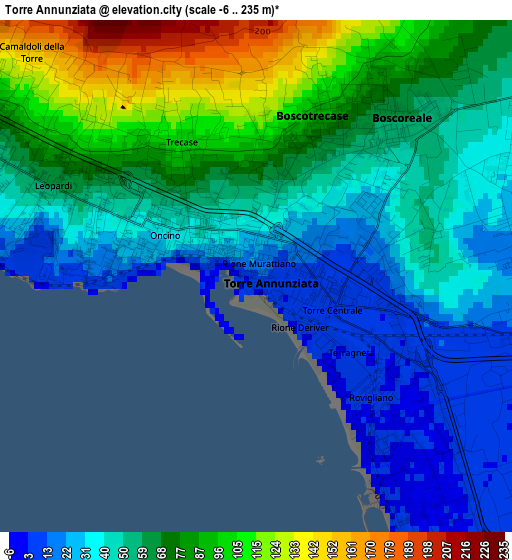
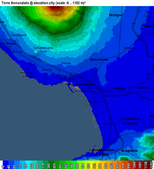
Below is the Elevation map of Torre Annunziata, which displays elevation range with different colors. Scale of the first map is from -6 to 235 m (-20 to 771 ft) with average elevation of 59.5 meters (=195 ft) [note 1]
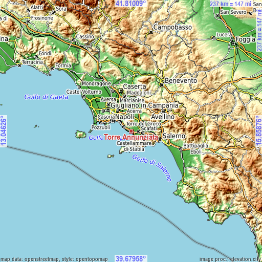
These maps also provides idea of topography and contour of this city, they are displayed at different zoom levels. More info about maps, scale and edge coordinates you can find below images.
| \ | Map #1 | Map #2 | Topo.Map |
| Scale [m] | -6..235 m | -6..1182 m | × |
| Scale [ft] | -20..771 ft | -20..3878 ft | × |
| Average | 59.5 m = 195 ft | 126.7 m = 416 ft | × |
| Width | 7.4 km = 4.6 mi | 14.81 km = 9.2 mi | 236.9 km = 147.2 mi |
| Height | 7.4 km = 4.6 mi | 14.81 km = 9.2 mi | 236.9 km = 147.2 mi |
| ↑Max Latitude | 40.786651° | 40.819916° | 41.81009° |
| Latitude at center | 40.75337° | 40.75337° | 40.75337° |
| ↓Min Latitude | 40.720072° | 40.686757° | 39.67958° |
| ← Min Longitude | 14.408565° | 14.364619° | 13.04626° |
| Longitude center | 14.45251° | 14.45251° | 14.45251° |
| →Max Longitude | 14.496455° | 14.540401° | 15.85876° |
Nearby cities:
Cities around Torre Annunziata sort by population:
• Torre del Greco elevation 59 m
8.2 km,  299°
299°
• Castellammare di Stabia 19 m
6.4 km,  153°
153°
• Scafati 16 m
7.2 km,  83°
83°
• Boscoreale 53 m
3.2 km,  48°
48°
• Pompei 11 m
3.8 km,  102°
102°
• Poggiomarino 29 m
9.1 km, 54°
• Sant'Antonio Abate 17 m
8.2 km,  115°
115°
• Terzigno 104 m
6.6 km,  31°
31°
• Santa Maria La Carità 30 m
6.4 km,  130°
130°
• Boscotrecase 84 m
2.3 km,  19°
19°
• Trecase 94 m
2.2 km,  325°
325°
• Casola di Napoli 178 m
9 km, 133°
Multilingual:
 En español:
Torre Annunziata elevación 15 m.
 En France:
Torre Annunziata élévation 15 m.
 Auf Deutsch:
Torre Annunziata höhe über dem Meeresspiegel ist 15 m.

Sources and notes:
- [note 1] Map square and city borders are not equal. Map elevation data is calculated only from area inside that square.
- [src 1] Elevation data from geonames database provided with same terms of usage.
- [src 2] The elevation map of Torre Annunziata is generated using elevation data from NASA's 3 arcsec (90m) resolution SRTM data.
- [src 3] Base (background) map © OpenStreetMap contributors tiles are generated by Geofabrik and OpenTopoMap.
Copyright & License:
This Torre Annunziata Elevation Map is licensed under CC BY-SA. You may reuse any part from this page, if you give a proper credit by linking to this URL:
 More info on terms of use page.