Treggiaia elevation
Treggiaia (Tuscany, Province of Pisa), Italy elevation is 71 meters and Treggiaia elevation in feet is 233 ft above sea level [src 1]. Treggiaia is a populated place (feature code) with elevation that is 251 meters (823 ft) smaller than average city elevation in Italy.
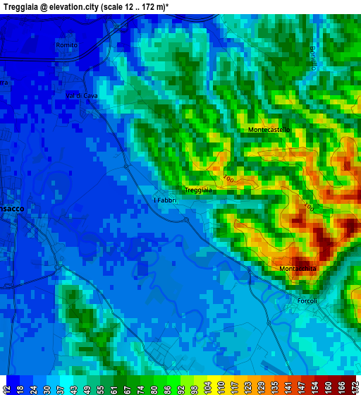
Below is the Elevation map of Treggiaia, which displays elevation range with different colors. Scale of the first map is from 12 to 172 m (39 to 564 ft) with average elevation of 47.3 meters (=155 ft) [note 1]
These maps also provides idea of topography and contour of this city, they are displayed at different zoom levels. More info about maps, scale and edge coordinates you can find below images.
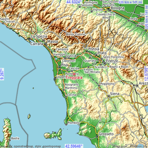
| \ | Map #1 | Topo.Map |
| Scale [m] | 12..172 m | × |
| Scale [ft] | 39..564 ft | × |
| Average | 47.3 m = 155 ft | × |
| Width | 7.07 km = 4.4 mi | 226.4 km = 140.7 mi |
| Height | 7.07 km = 4.4 mi | 226.4 km = 140.7 mi |
| ↑Max Latitude | 43.654853° | 44.6324° |
| Latitude at center | 43.62305° | 43.62305° |
| ↓Min Latitude | 43.59123° | 42.59646° |
| ← Min Longitude | 10.629305° | 9.267° |
| Longitude center | 10.67325° | 10.67325° |
| →Max Longitude | 10.717195° | 12.0795° |
Nearby cities:
Cities around Treggiaia sort by population:
• Pontedera elevation 16 m
5.5 km,  321°
321°
• Ponsacco 22 m
3.8 km,  270°
270°
• Capannoli 39 m
3.8 km,  179°
179°
• Le Casine-Perignano-Spinelli 23 m
7.7 km,  250°
250°
• Montecalvoli 17 m
7 km,  354°
354°
• Forcoli 38 m
3.3 km,  129°
129°
• La Rotta 25 m
4 km,  5°
5°
• San Pietro Belvedere 130 m
5.9 km,  185°
185°
• Selvatelle 49 m
6.8 km,  168°
168°
• Il Romito 23 m
3.7 km, 322°
• Marti 97 m
6.5 km,  57°
57°
• Val di Cava 22 m
2.6 km,  310°
310°
Multilingual:
 En español:
Treggiaia elevación 71 m.
 En France:
Treggiaia élévation 71 m.
 Auf Deutsch:
Treggiaia höhe über dem Meeresspiegel ist 71 m.

Sources and notes:
- [note 1] Map square and city borders are not equal. Map elevation data is calculated only from area inside that square.
- [src 1] Elevation data from geonames database provided with same terms of usage.
- [src 2] The elevation map of Treggiaia is generated using elevation data from NASA's 3 arcsec (90m) resolution SRTM data.
- [src 3] Base (background) map © OpenStreetMap contributors tiles are generated by Geofabrik and OpenTopoMap.
Copyright & License:
This Treggiaia Elevation Map is licensed under CC BY-SA. You may reuse any part from this page, if you give a proper credit by linking to this URL:
 More info on terms of use page.