Trentola-Ducenta elevation
Trentola-Ducenta (Campania, Provincia di Caserta), Italy elevation is 46 meters and Trentola-Ducenta elevation in feet is 151 ft above sea level [src 1]. Trentola-Ducenta is a seat of a third-order administrative division (feature code) with elevation that is 276 meters (906 ft) smaller than average city elevation in Italy.
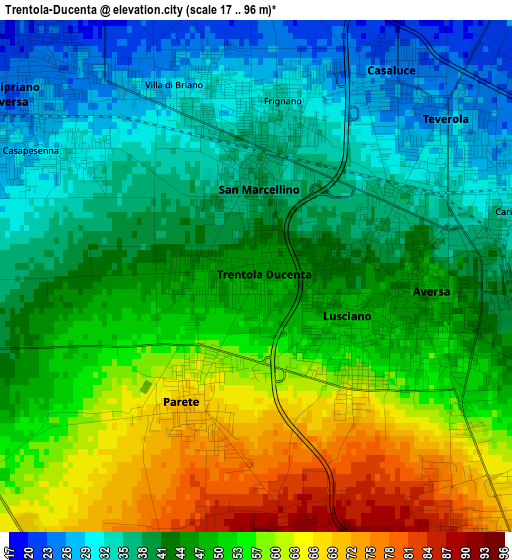
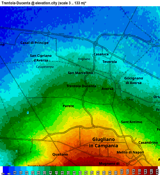
Below is the Elevation map of Trentola-Ducenta, which displays elevation range with different colors. Scale of the first map is from 17 to 96 m (56 to 315 ft) with average elevation of 46.8 meters (=154 ft) [note 1]
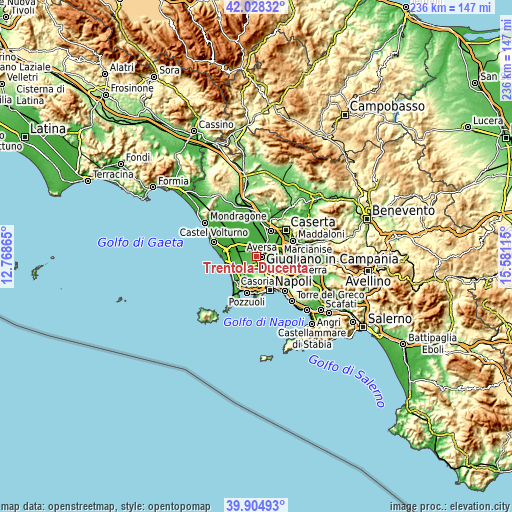
These maps also provides idea of topography and contour of this city, they are displayed at different zoom levels. More info about maps, scale and edge coordinates you can find below images.
| \ | Map #1 | Map #2 | Topo.Map |
| Scale [m] | 17..96 m | 3..133 m | × |
| Scale [ft] | 56..315 ft | 10..436 ft | × |
| Average | 46.8 m = 154 ft | 43.8 m = 144 ft | × |
| Width | 7.38 km = 4.6 mi | 14.76 km = 9.2 mi | 236.1 km = 146.7 mi |
| Height | 7.38 km = 4.6 mi | 14.76 km = 9.2 mi | 236.1 km = 146.7 mi |
| ↑Max Latitude | 41.00834° | 41.041494° | 42.02832° |
| Latitude at center | 40.97517° | 40.97517° | 40.97517° |
| ↓Min Latitude | 40.941983° | 40.90878° | 39.90493° |
| ← Min Longitude | 14.130955° | 14.087009° | 12.76865° |
| Longitude center | 14.1749° | 14.1749° | 14.1749° |
| →Max Longitude | 14.218845° | 14.262791° | 15.58115° |
Nearby cities:
Cities around Trentola-Ducenta sort by population:
• Aversa elevation 48 m
2.7 km,  95°
95°
• Lusciano 48 m
1.4 km,  113°
113°
• San Cipriano d'Aversa 23 m
4.5 km,  305°
305°
• San Marcellino 37 m
1.7 km,  2°
2°
• Teverola 26 m
3.6 km,  50°
50°
• Parete 66 m
2.1 km,  211°
211°
• Gricignano di Aversa 31 m
4.7 km,  83°
83°
• Casaluce 27 m
3.1 km,  35°
35°
• Frignano 33 m
2.6 km,  7°
7°
• Carinaro 31 m
3.9 km, 77°
• Casapesenna 30 m
3.7 km,  299°
299°
• Villa di Briano 30 m
3 km,  336°
336°
Multilingual:
 En español:
Trentola-Ducenta elevación 46 m.
 En France:
Trentola-Ducenta élévation 46 m.
 Auf Deutsch:
Trentola-Ducenta höhe über dem Meeresspiegel ist 46 m.

Sources and notes:
- [note 1] Map square and city borders are not equal. Map elevation data is calculated only from area inside that square.
- [src 1] Elevation data from geonames database provided with same terms of usage.
- [src 2] The elevation map of Trentola-Ducenta is generated using elevation data from NASA's 3 arcsec (90m) resolution SRTM data.
- [src 3] Base (background) map © OpenStreetMap contributors tiles are generated by Geofabrik and OpenTopoMap.
Copyright & License:
This Trentola-Ducenta Elevation Map is licensed under CC BY-SA. You may reuse any part from this page, if you give a proper credit by linking to this URL:
 More info on terms of use page.