Trivignano Udinese elevation
Trivignano Udinese (Friuli Venezia Giulia, Provincia di Udine), Italy elevation is 43 meters and Trivignano Udinese elevation in feet is 141 ft above sea level [src 1]. Trivignano Udinese is a seat of a third-order administrative division (feature code) with elevation that is 279 meters (915 ft) smaller than average city elevation in Italy.
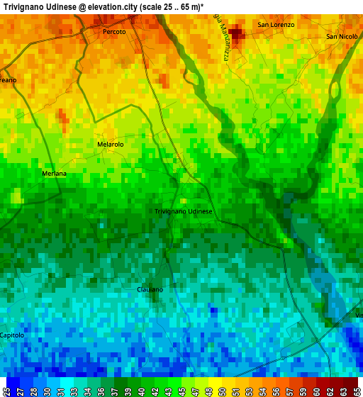
Below is the Elevation map of Trivignano Udinese, which displays elevation range with different colors. Scale of the first map is from 25 to 65 m (82 to 213 ft) with average elevation of 41.4 meters (=136 ft) [note 1]
These maps also provides idea of topography and contour of this city, they are displayed at different zoom levels. More info about maps, scale and edge coordinates you can find below images.
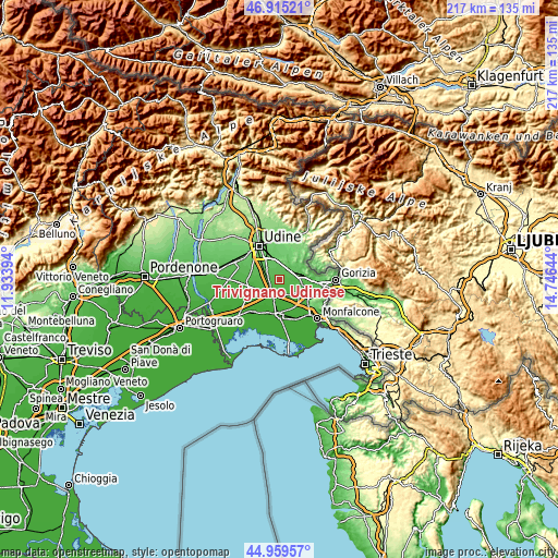
| \ | Map #1 | Topo.Map |
| Scale [m] | 25..65 m | × |
| Scale [ft] | 82..213 ft | × |
| Average | 41.4 m = 136 ft | × |
| Width | 6.8 km = 4.2 mi | 217.4 km = 135.1 mi |
| Height | 6.8 km = 4.2 mi | 217.4 km = 135.1 mi |
| ↑Max Latitude | 45.976558° | 46.91521° |
| Latitude at center | 45.94601° | 45.94601° |
| ↓Min Latitude | 45.915445° | 44.95957° |
| ← Min Longitude | 13.296245° | 11.93394° |
| Longitude center | 13.34019° | 13.34019° |
| →Max Longitude | 13.384135° | 14.74644° |
Nearby cities:
Cities around Trivignano Udinese sort by population:
• Manzano elevation 66 m
5.5 km,  30°
30°
• San Giovanni al Natisone 61 m
5.5 km,  59°
59°
• Palmanova 27 m
5.1 km,  207°
207°
• Percoto 58 m
3.5 km,  337°
337°
• Santa Maria la Longa 40 m
4.2 km,  251°
251°
• Ialmicco 29 m
3.7 km,  172°
172°
• Lauzacco 60 m
6.1 km,  310°
310°
• San Vito al Torre 25 m
6.2 km,  153°
153°
• Pavia di Udine 65 m
6.1 km,  332°
332°
• Sottoselva 30 m
4 km,  197°
197°
• Visco 22 m
6 km, 173°
• Chiopris 33 m
5.4 km,  113°
113°
Multilingual:
 En español:
Trivignano Udinese elevación 43 m.
 En France:
Trivignano Udinese élévation 43 m.
 Auf Deutsch:
Trivignano Udinese höhe über dem Meeresspiegel ist 43 m.

Sources and notes:
- [note 1] Map square and city borders are not equal. Map elevation data is calculated only from area inside that square.
- [src 1] Elevation data from geonames database provided with same terms of usage.
- [src 2] The elevation map of Trivignano Udinese is generated using elevation data from NASA's 3 arcsec (90m) resolution SRTM data.
- [src 3] Base (background) map © OpenStreetMap contributors tiles are generated by Geofabrik and OpenTopoMap.
Copyright & License:
This Trivignano Udinese Elevation Map is licensed under CC BY-SA. You may reuse any part from this page, if you give a proper credit by linking to this URL:
 More info on terms of use page.