Vaprio D'Agogna elevation
Vaprio D'Agogna (Piedmont, Provincia di Novara), Italy elevation is 234 meters and Vaprio D'Agogna elevation in feet is 768 ft above sea level [src 1]. Vaprio D'Agogna is a seat of a third-order administrative division (feature code) with elevation that is 88 meters (289 ft) smaller than average city elevation in Italy.
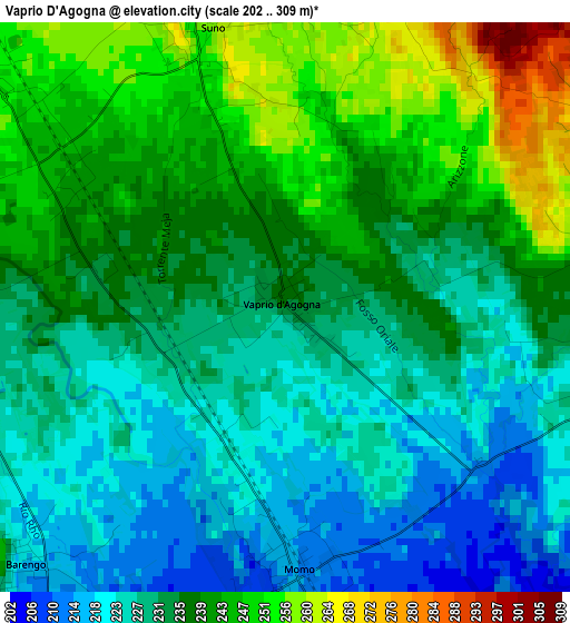
Below is the Elevation map of Vaprio D'Agogna, which displays elevation range with different colors. Scale of the first map is from 202 to 309 m (663 to 1014 ft) with average elevation of 234.6 meters (=770 ft) [note 1]
These maps also provides idea of topography and contour of this city, they are displayed at different zoom levels. More info about maps, scale and edge coordinates you can find below images.
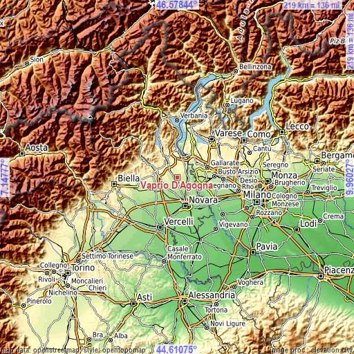
| \ | Map #1 | Topo.Map |
| Scale [m] | 202..309 m | × |
| Scale [ft] | 663..1014 ft | × |
| Average | 234.6 m = 770 ft | × |
| Width | 6.84 km = 4.3 mi | 218.8 km = 136 mi |
| Height | 6.84 km = 4.3 mi | 218.8 km = 136 mi |
| ↑Max Latitude | 45.633957° | 46.57844° |
| Latitude at center | 45.60322° | 45.60322° |
| ↓Min Latitude | 45.572466° | 44.61075° |
| ← Min Longitude | 8.510075° | 7.14777° |
| Longitude center | 8.55402° | 8.55402° |
| →Max Longitude | 8.597965° | 9.96027° |
Nearby cities:
Cities around Vaprio D'Agogna sort by population:
• Oleggio elevation 207 m
6.9 km,  96°
96°
• Momo 214 m
3.2 km,  180°
180°
• Suno 265 m
3.2 km,  346°
346°
• Marano Ticino 257 m
6.6 km,  65°
65°
• Divignano 334 m
7.5 km,  28°
28°
• Cavaglio D'Agogna 245 m
5.4 km,  281°
281°
• Fontaneto D'Agogna 265 m
7.4 km,  307°
307°
• Mezzomerico 253 m
4.5 km, 65°
• Bogogno 283 m
6.8 km, 347°
• Barengo 218 m
4.3 km,  225°
225°
• Cressa 270 m
6 km,  324°
324°
• Cavaglietto 237 m
4 km,  268°
268°
Multilingual:
 En español:
Vaprio D'Agogna elevación 234 m.
 En France:
Vaprio D'Agogna élévation 234 m.
 Auf Deutsch:
Vaprio D'Agogna höhe über dem Meeresspiegel ist 234 m.

Sources and notes:
- [note 1] Map square and city borders are not equal. Map elevation data is calculated only from area inside that square.
- [src 1] Elevation data from geonames database provided with same terms of usage.
- [src 2] The elevation map of Vaprio D'Agogna is generated using elevation data from NASA's 3 arcsec (90m) resolution SRTM data.
- [src 3] Base (background) map © OpenStreetMap contributors tiles are generated by Geofabrik and OpenTopoMap.
Copyright & License:
This Vaprio D'Agogna Elevation Map is licensed under CC BY-SA. You may reuse any part from this page, if you give a proper credit by linking to this URL:
 More info on terms of use page.