Vernate elevation
Vernate (Lombardy, Città metropolitana di Milano), Italy elevation is 101 meters and Vernate elevation in feet is 331 ft above sea level [src 1]. Vernate is a seat of a third-order administrative division (feature code) with elevation that is 221 meters (725 ft) smaller than average city elevation in Italy.
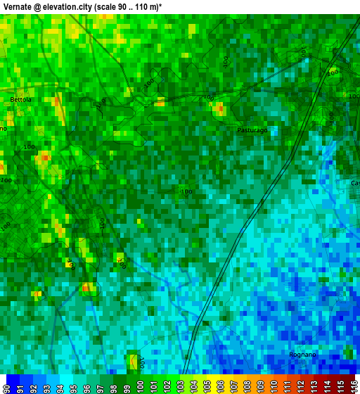
Below is the Elevation map of Vernate, which displays elevation range with different colors. Scale of the first map is from 90 to 110 m (295 to 361 ft) with average elevation of 97.4 meters (=320 ft) [note 1]
These maps also provides idea of topography and contour of this city, they are displayed at different zoom levels. More info about maps, scale and edge coordinates you can find below images.
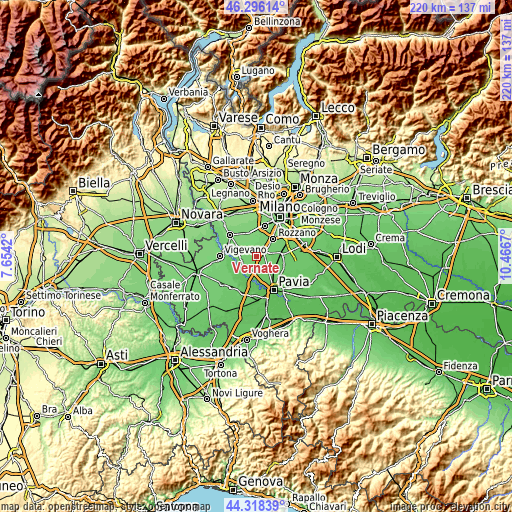
| \ | Map #1 | Topo.Map |
| Scale [m] | 90..110 m | × |
| Scale [ft] | 295..361 ft | × |
| Average | 97.4 m = 320 ft | × |
| Width | 6.87 km = 4.3 mi | 219.9 km = 136.6 mi |
| Height | 6.87 km = 4.3 mi | 219.9 km = 136.6 mi |
| ↑Max Latitude | 45.346784° | 46.29614° |
| Latitude at center | 45.31589° | 45.31589° |
| ↓Min Latitude | 45.284979° | 44.31839° |
| ← Min Longitude | 9.016505° | 7.6542° |
| Longitude center | 9.06045° | 9.06045° |
| →Max Longitude | 9.104395° | 10.4667° |
Nearby cities:
Cities around Vernate sort by population:
• Casorate Primo elevation 99 m
3.4 km,  261°
261°
• Binasco 99 m
3.1 km,  57°
57°
• Casarile 96 m
3.4 km,  88°
88°
• Bubbiano 105 m
3.8 km,  289°
289°
• Moncucco 101 m
1.8 km,  249°
249°
• Santa Corinna 99 m
3.5 km,  39°
39°
• Bettola 103 m
3.6 km,  299°
299°
• Trovo 96 m
4.2 km,  208°
208°
• Mairano 104 m
4.7 km,  8°
8°
• Rognano 93 m
3.8 km,  142°
142°
• Battuda 92 m
4.8 km,  163°
163°
• Calvignasco 102 m
2.8 km, 293°
Multilingual:
 En español:
Vernate elevación 101 m.
 En France:
Vernate élévation 101 m.


Sources and notes:
- [note 1] Map square and city borders are not equal. Map elevation data is calculated only from area inside that square.
- [src 1] Elevation data from geonames database provided with same terms of usage.
- [src 2] The elevation map of Vernate is generated using elevation data from NASA's 3 arcsec (90m) resolution SRTM data.
- [src 3] Base (background) map © OpenStreetMap contributors tiles are generated by Geofabrik and OpenTopoMap.
Copyright & License:
This Vernate Elevation Map is licensed under CC BY-SA. You may reuse any part from this page, if you give a proper credit by linking to this URL:
 More info on terms of use page.