Villachiara elevation
Villachiara (Lombardy, Provincia di Brescia), Italy elevation is 74 meters and Villachiara elevation in feet is 243 ft above sea level [src 1]. Villachiara is a seat of a third-order administrative division (feature code) with elevation that is 248 meters (814 ft) smaller than average city elevation in Italy.
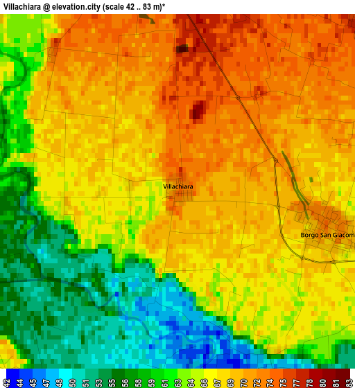
Below is the Elevation map of Villachiara, which displays elevation range with different colors. Scale of the first map is from 42 to 83 m (138 to 272 ft) with average elevation of 65.4 meters (=215 ft) [note 1]
These maps also provides idea of topography and contour of this city, they are displayed at different zoom levels. More info about maps, scale and edge coordinates you can find below images.
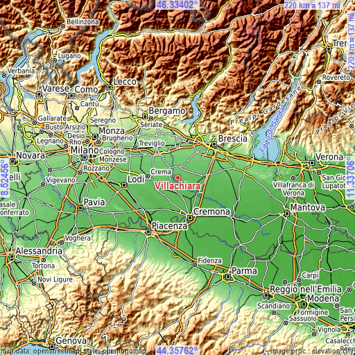
| \ | Map #1 | Topo.Map |
| Scale [m] | 42..83 m | × |
| Scale [ft] | 138..272 ft | × |
| Average | 65.4 m = 215 ft | × |
| Width | 6.87 km = 4.3 mi | 219.8 km = 136.6 mi |
| Height | 6.87 km = 4.3 mi | 219.7 km = 136.5 mi |
| ↑Max Latitude | 45.385323° | 46.33402° |
| Latitude at center | 45.35445° | 45.35445° |
| ↓Min Latitude | 45.32356° | 44.35762° |
| ← Min Longitude | 9.886865° | 8.52456° |
| Longitude center | 9.93081° | 9.93081° |
| →Max Longitude | 9.974755° | 11.33706° |
Nearby cities:
Cities around Villachiara sort by population:
• Orzinuovi elevation 88 m
5.3 km,  353°
353°
• Quinzano d'Oglio 62 m
7.5 km,  126°
126°
• Soncino 81 m
7.1 km,  316°
316°
• Borgo San Giacomo 71 m
3 km,  103°
103°
• San Paolo 74 m
7.5 km,  74°
74°
• Orzivecchi 88 m
7.8 km,  19°
19°
• Casalmorano 67 m
7.8 km,  198°
198°
• Genivolta 64 m
4.8 km,  239°
239°
• Azzanello 65 m
4.7 km,  190°
190°
• Cumignano sul Naviglio 75 m
7.4 km,  270°
270°
• Ticengo 78 m
8.2 km,  281°
281°
• Castelvisconti 58 m
5.5 km,  171°
171°
Multilingual:
 En español:
Villachiara elevación 74 m.
 En France:
Villachiara élévation 74 m.
 Auf Deutsch:
Villachiara höhe über dem Meeresspiegel ist 74 m.

Sources and notes:
- [note 1] Map square and city borders are not equal. Map elevation data is calculated only from area inside that square.
- [src 1] Elevation data from geonames database provided with same terms of usage.
- [src 2] The elevation map of Villachiara is generated using elevation data from NASA's 3 arcsec (90m) resolution SRTM data.
- [src 3] Base (background) map © OpenStreetMap contributors tiles are generated by Geofabrik and OpenTopoMap.
Copyright & License:
This Villachiara Elevation Map is licensed under CC BY-SA. You may reuse any part from this page, if you give a proper credit by linking to this URL:
 More info on terms of use page.